Nawabganj Upazila HQ
| township, fourth-level administrative division, local government
Bangladesh /
Dhaka /
Dohar /
World
/ Bangladesh
/ Dhaka
/ Dohar
World / Bangladesh / Dhaka / Dhaka / Dhaka
township, fourth-level administrative division, local government
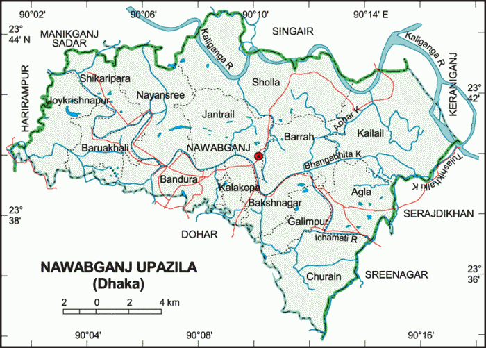
Nawabganj Upazila (Dhaka district) with an area of 244.81 sq km, is bounded by Singair upazila on the north, Dohar upazila on the south, Keraniganj, Sirajdikhan and Sreenagar upazilas on the east, Harirampur and Manikganj sadar upazilas on the west. Main rivers are Dhaleshwari, Ichamati and Kaliganga.
Nawabganj is located at 23.6667°N 90.1667°E. It has 47,411 units of house hold. Nawabganj (Town) consists of 7 mouzas. The town has an area of 1.93 sq km. It has a population of 11486; male 51.35%, female 48.65%; density of population is 5951 per sq km. The literacy rate among the town people is 53.1%. It is believed that Khwaja Nawab Salimullah inaugurated this thana town towards the end of the nineteenth century. In honour of the Nawab this place is named Nawabganj.
Nawabganj thana, now an upazila, was established in 1974. The upazila consists of 14 union parishads, 178 mouzas and 305 villages.
As of 1991 Bangladesh census, Population 269189: male 49.31%, female 50.69%; Muslim 77.19%, Hindu 20.74%, Christian 2.04%, Buddhist 0.01% and others 0.02%.
Religious institutions Mosque 475, temple 192, church 5, tomb 2, most noted of which is tomb of Hazrat Afaz Uddin Shah (R).
Average literacy 34.5%; male 38.5% and female 30.6%. Educational institutions: college 7, high school 24, junior high school 6, madrasa 9, government primary school 90, non-government primary school 19.
Main occupations Agriculture 22.1%, agricultural labourer 13.27%, wage labourer 4.5%, fishing 2.9%, weaving 4.37%, industry 1.3%, commerce 12.2%, service 18.54%, construction 2.98%, house renting out 3.45%, and others 14.39%.
Land use: Total cultivable land 18208.01 hectares, fallow land 6272.76 hectares; single crop 47.5%, double crop 37.8% and treble crop land 14.7%.
Land control: Among the peasants 29% are landless, 30% small, 32% intermediate and 9% rich; cultivable land per head 0.07 hectare.
Fisheries, dairies, poultries Poultry 39, dairy 140 and fishery 223.
Cottage industries: Weaving, bamboo and cane work, goldsmith, blacksmith, tailoring, wood work, etc.
Main exports: cotton sari and lungi.
Communication facilities Roads: pucca 12 km, semi pucca 28 km and mud road 438 km; waterways 11 nautical mile.
Health centres: Upazila health complex 1, satellite clinic 2 and family planning centre 4.
NGO activities Operationally important NGOs are brac, asa, grameen bank, Agrani Samaj Unnayan Sangstha, proshika and Grameen Kalyan Parishad.
Nearby cities:
Coordinates: 23°39'44"N 90°9'7"E
- Keraniganj Upazila 14 km
- Lohajang Upazila 15 km
- Matlab Upazila (North) Area 46 km
- Rupganj Upazila 51 km
- Kapashia Upazila 75 km
- Gafargaon Upazila 103 km
- Dhobaura Upazila 172 km
- Patiya Upazila (পটিয়া) 223 km
- Banshkhali Upazila (বাঁশখালী উপজেলা) 239 km
- Chandanaish Upazila 239 km
- Boro Rajpara,Nawabgonj,Dhaka 1.9 km
- Nawabgonj Upazila 2.1 km
- Mohabbatpur village 2.4 km
- Bandura 3.6 km
- CHAR KHALSI BY. ABDUL ALIM 4.3 km
- NAYANSREE (by rakib & rafiu) 5.4 km
- TUITAL 5.9 km
- basta 7.1 km
- - 14 km
- Dhaka Division 57 km
Comments