Ramgarh Upazila HQ. Bangladesh
Bangladesh /
Khagrachhari /
Ramgarh /
World
/ Bangladesh
/ Khagrachhari
/ Ramgarh
World / Bangladesh / Chittagong / Khagrachari / Khagrachari
township, subdistrict, fourth-level administrative division, local government
Ramgarh (Bengali: রামগড়) is an Upazila of Khagrachari District in the Division of Chittagong, Bangladesh.Ramgarh is located at 22.9667°N 91.7000°E .
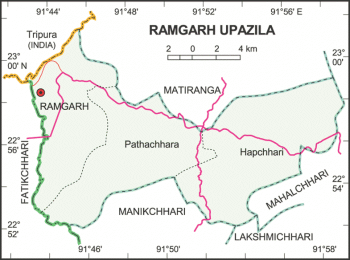
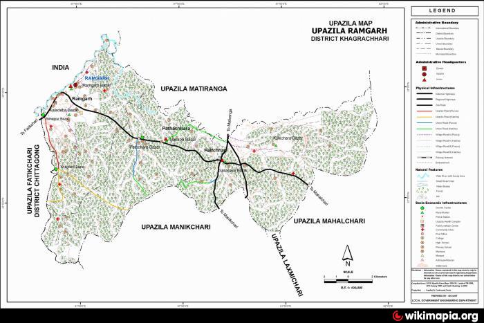
Ramgarh Upazila with an area of 207.69 sq km, is bounded by Indian State of Tripura and Matiranga upazila on the north, Manikchhari and Lakshmichhari upazilas on the south, Mahalchhari upazila on the east and Fatikchhari upazila on the west. Forests, hills and tilas cover a substantial portion out of the upazila.
Ramgarh (Town) consists of two mouzas. It has an area of 64.75 sq km. The town has a population of 23856; male 53.42% and female 46.58%; population density per sq km 368. Literacy rate among the town people is 36%. The town has three dakbungalows.
Ramgarh thana was established in 1905 and was turned into an upazila in 1983. The upazila consists of 3 union parishads/wards, 11 mouzas/Mahallas and 82 villages. It has 9304 units of house hold and total area 240.87 km².
Archaeological heritage and relics: Mohamuni Buddhist monastery (built by the Mun Dynasty), SDO bungalow.
Historical events: The present Bangladesh Rifles (renamed BBG) were formed on 21st June 1795 at Ramgarh in the name of 'Ramgarh Local Battalion'.
Religious institutions: Mosque 42, Buddhist monastery and Keyang 22, Hindu temple 11 and Church 1, most noted of which are Ramgarh Central Jami Mosque, Mohamuni Buddhist Monastery.
As of the 1991 Bangladesh census: Population 44217; male 53.01%, female 46.99%; Muslim 64.37%, Buddhist 21.21%, Hindu 13.93% and others 0.49%.
Literacy and educational institutions: Average literacy 29.1%; male 38.9% and female 17.8%. Educational institutions: college 1, government high school 1, non-government girl's high school 1, junior high school 5, madrasa 4, government primary school 41, non-government primary school 11, community primary school 3, and satellite school 3. Noted institutions: Ramgarh Government High School (1952) and Ramgarh Girl's High School (1964).
Cultural organisations: Public library 1, press club 1, officers club 1, ladies' club 1, stadium 1 and playground 5.
Main occupations: Agriculture 33.14%, agricultural labourer 19.57%, wage labourer 8.09%, commerce 10%, services 10.91%, wood cutter 3% and others 15.29%.
Land use: Total cultivable land 3224.40 hectares; fallow land 283.29 hectares; single crop 54.26%, double crop 33.83% and treble crop land 11.91%; forest 1854.55 hectares.
Land control: Among the peasants, 11.35% are landless, 35.90% small, 23.65% intermediate, 5.45% rich and 23.65% marginal; cultivable land per head 0.07%.
Fisheries, dairies, poultries Fishery 7, dairy 2, poultry 15 and hatchery (fish) 1.
Communication facilities- Roads: pucca 12.5 km, semi pucca 11.5 km and mud road 165 km.
Manufactories: Intoxicating drink (wine) factory 1, sawmill 7, paddy mill 12, plywood factory 2, ice factory 1.
Cottage industries: Handloom 2, sewing 1, goldsmith 11, blacksmith 10, wood work 35 and welding 4.
NGO activities: Operationally important NGOs are brac and IDF.
Health centres: Upazila health complex 1, health and family welfare centre 2 and Islamic mission health centre 1.
Nearby cities:
Coordinates: 22°58'54"N 91°44'30"E
- Patiya Upazila (পটিয়া) 70 km
- Chandanaish Upazila 81 km
- Banshkhali Upazila (বাঁশখালী উপজেলা) 90 km
- Matlab Upazila (North) Area 133 km
- Rupganj Upazila 163 km
- Lohajang Upazila 167 km
- Keraniganj Upazila 175 km
- Kapashia Upazila 192 km
- Gafargaon Upazila 218 km
- Dhobaura Upazila 285 km
- Ramkot Hill 1.7 km
- Sabroom Railway Station (SBRM) 5.5 km
- Bagan bazar Union (বাগান বাজার) 8.7 km
- Rupai Chari RD Block. 11 km
- NANDI PROPERTY 11 km
- Manu Bazar Railway Station (MUBR) 13 km
- Fatikchhari Upazila (ফটিকছড়ি উপজেলা) 23 km
- Khagrachari District 33 km
- Chattogram District Area 59 km
- Tripura 87 km