Mission Creek Waterfall (site) (San Francisco, California)
USA /
California /
San Francisco /
San Francisco, California
World
/ USA
/ California
/ San Francisco
World / United States / California
creek, place with historical importance, historical layer / disappeared object
Urban creek waterfall, described by the 1776 de Anza expedition.
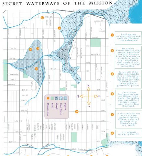
The creek was the original water source, and reason for location, of Mission Dolores in 1776. Entirely buried now in conduits, the creek still runs east from Twin Peaks down 18th Street to what was a small lake, Laguna de los Dolores, near the Mission on Dolores & 17th streets, then to what formerly was a large South of Market marsh, and now to its current China Basin outlet. (Reference: Doris Sloan, Geology of the SF Bay Region, UCPress 2006, p.111.)
The creek was the original water source, and reason for location, of Mission Dolores in 1776. Entirely buried now in conduits, the creek still runs east from Twin Peaks down 18th Street to what was a small lake, Laguna de los Dolores, near the Mission on Dolores & 17th streets, then to what formerly was a large South of Market marsh, and now to its current China Basin outlet. (Reference: Doris Sloan, Geology of the SF Bay Region, UCPress 2006, p.111.)
Wikipedia article: http://en.wikipedia.org/wiki/Mission_Creek
Nearby cities:
Coordinates: 37°45'39"N 122°26'6"W
- Former Frenchman Creek Camp (site) 301 km
- Redfield Canyon 1244 km
- Widgeon Creek Nature Reserve 1307 km
- Adobe Creek Reservoir 1678 km
- Mill Creek Ravine 1882 km
- Headless Creek, Canada 2634 km
- Cathedral Creek 2699 km
- Peninsula State Park 3023 km
- McCormick's Creek State Park 3093 km
- Manley Hot Springs, AK 3547 km
- Eureka Valley 0.2 km
- Castro District 0.3 km
- Noe Valley 1.4 km
- Haight-Ashbury 1.4 km
- Twin Peaks 1.6 km
- Parnassus Heights 1.9 km
- Western Addition 2.1 km
- Inner Sunset 2.6 km
- Golden Gate Park 4.2 km
- San Francisco Bay 14 km