Moheshpur Upazila HQ
Bangladesh /
Jhanaydah /
Kotchandpur /
World
/ Bangladesh
/ Jhanaydah
/ Kotchandpur
World / Bangladesh / Khulna / Jessore / Jhenaidah
township, fourth-level administrative division, local government
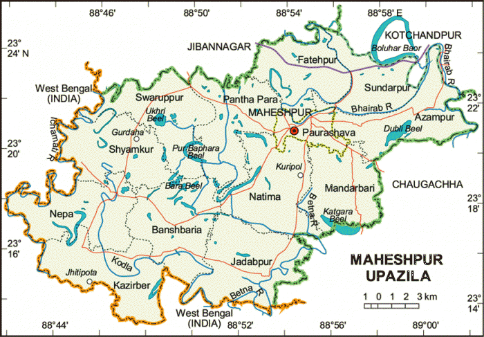
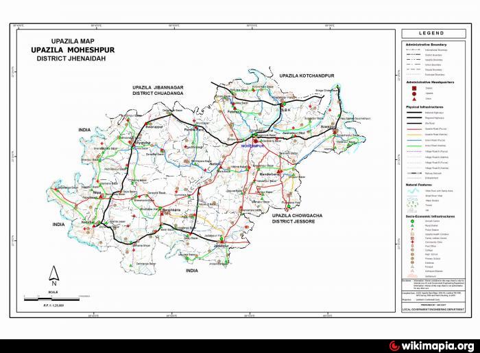
Maheshpur Upazila (Jhenaidah district) with an area of 405.44 sq km, is bounded by Jibannagar and Kotchandpur upazilas on the north, Chaugachha upazila and West Bengal (India) on the south, Chaugachha upazila on the east, West Bengal of India on the west. Kobadak and Betna rivers and Boldahar Baor are notable.
The location of Maheshpur town is 23.357316N 88.9157991E. Maheshpur (Town) consists of 9 wards and 14 mahallas. The area of the town is 11.47 sq km. The town has a population of 23273; male 51.26% and female 48.74%; population density per sq km 2029. Literacy rate among the town people is 31.9%.
Maheshpur thana was turned into an upazila in 1983. The upazila consists of one municipality, 15 union parishads, 159 mouzas and 194 villages.
As of the 1991 Bangladesh census, Population 246350; male 51.22%, female 48.78%; Muslim 95.59%, Hindu 4.31% and others 0.10%.
Religious institutions: Mosque 335, temple 21; noted which are Maheshpur Jami Mosque, Shiva Mandir and Sreepat Mandir.
Literacy and educational institutions: Average literacy 22.2%; male 28.2% and female 15.8%. Educational institutions: college 4, high school 30, madrasa 12, government primary school 66, non-government primary school 68, technical institution 1. Noted educational institution: Maheshpur High School (1863).
Main occupations: Agriculture 47.37%, agricultural labourer 32.36%, wage labourer 1.44%, commerce 9.40%, service 2.22% and others 7.21%.
Land use: Total cultivable land 33039.25 hectares, fallow land 249.29 hectares; single crop 21.66%, double crop 63.55% and treble crop land 14.79%.
Land control: Among the peasants, 16% are landless, 37% small, 32% intermediate and 15% rich; cultivable land per head 0.13 hectare.
Main crops Paddy, jute, wheat, sugarcane, onion, garlic, cotton.
Dairies, poultries Dairy and poultry 3.
Communication facilities- Roads: pucca 20 km, semi pucca 40 km and mud road 718 km; waterways 4 nautical mile.
Manufactories: Ice factory 4 and welding 20.
Cottage industries: Weaving 35, goldsmith 45, blacksmith 95, potteries 15, wood work 165.
NGO activities: Operationally important NGOs are brac, asa, grameen bank, proshika, Ahsania Mission, Wave and RICO.
Health centres: Upazila health complex 1, family planning clinic 11, satellite clinic 4.
Nearby cities:
Coordinates: 23°21'19"N 88°54'50"E
- Abhaynagar Upazila HQ 57 km
- Fakirhat Upazila HQ 100 km
- Koyra Upzila HQ 114 km
- Kachua Upazila HQ 123 km
- Sarishabari Upazila 184 km
- Bholahat Upazila HQ 193 km
- Gobindaganj Upazila 211 km
- Shaghatta Upazila 218 km
- Maidi Vdc 658 km
- Samote Union Council 1879 km
- Moheshpur Upazila Health Complex 1.4 km
- Khalishpur Bazar 4.9 km
- Mandartala High School 8.4 km
- HOUSE OF SAIDUL ISLAM (MILON) 8.4 km
- Bangladesh Agiculture Development Corporation,Dattanagar 9 km
- Dattanagar S.M firm High school 10 km
- Mamabhagina High School 11 km
- RAJKOLE VILLAGE 15 km
- Chuadanga District 28 km
- Khulna Division 66 km