Seminole Canyon State Park & Historic Site
USA /
Texas /
Cienegas Terrace /
U.S. Route 90
World
/ USA
/ Texas
/ Cienegas Terrace
World / United States / Texas
park, state park
Highway 90
Comstock, TX 78837
(432) 292-4464
www.tpwd.state.tx.us/spdest/findadest/parks/seminole_ca...
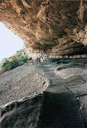
Desert park that has 10,000-12,000 year old pictographs under the overhanging canyon ledges where the native people used to live. This park has a nice campground. The best time to camp is in the Spring. The Summer is too hot, and the Fall can have occasional blooms of the insect population of biblical proportions.
Comstock, TX 78837
(432) 292-4464
www.tpwd.state.tx.us/spdest/findadest/parks/seminole_ca...
Desert park that has 10,000-12,000 year old pictographs under the overhanging canyon ledges where the native people used to live. This park has a nice campground. The best time to camp is in the Spring. The Summer is too hot, and the Fall can have occasional blooms of the insect population of biblical proportions.
Wikipedia article: http://en.wikipedia.org/wiki/Texas_state_parks
Nearby cities:
Coordinates: 29°41'4"N 101°18'7"W
- Boquillas Canyon 164 km
- Punta de la Sierra 209 km
- Study Butte, Texas 223 km
- Big Bend National Park 226 km
- Monahans Sandhills State Park 267 km
- Davis Mountains State Park 275 km
- Guadalupe Mountains National Park 437 km
- Cumbres de Majalca National Park 522 km
- Samalayuca Dune Fields 546 km
- Franklin Mountains State Park 559 km
- Lake Amistad 24 km
- Langtry, Texas 28 km
- 48TE 4M Ranch Airfield 46 km
- The Herradura Oxbow 51 km
- Dryden 88 km
- Terrell County Airport 97 km
- Baxter's Cruve 111 km
- Fort Lancaster State Historic Site 116 km
- Sanderson, Texas 119 km
- Sheffield, Texas 122 km