American Tower Greensboro NC Site
USA /
North Carolina /
Pleasant Hill /
World
/ USA
/ North Carolina
/ Pleasant Hill
World / United States / North Carolina
radio broadcasting tower, mobile phone transmitter / mast
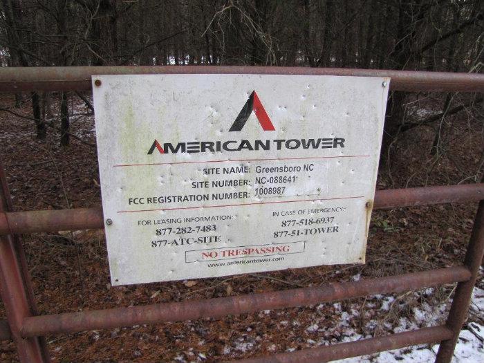
Site Number: 88641
Address: LIBERTY RADIO TOWER 5010
City: Liberty
State: North Carolina
Zip Code: 27298-8159
Latitude:
Longitude:
35 - 54 - 2.49 N 35.901
79 - 34 - 41.08 W -79.578
maps.google.com/maps?q=35.901,%20-79.578
www.mapquest.com/?q=35.901,%20-79.578
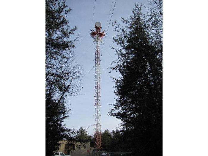
Tower Data
Tower Number: 88641
Structure Height (AGL): 224 ft.
Structure Height (AMSL): 957 ft.
Clearance: 3 ft.
Total Height (AMSL): 960 ft.
Type: Guyed
FAA #: 2002-ASO-6410-OE
FCC #: 1008987
Site Specs
MTA: Charlotte-Greensboro-Greenville-Raleigh
BTA: Greensboro--Winston
MSA/RSA: Greensboro, NC
Ground Elevation AMSL: 733 ft.
Datum: NAD83
County: RANDOLPH
Region: USA
Comments:
Driving Instructions: From Hwy 64 in Siler City turn N. on SR 1004 (Martin Luther King Blvd).Go 5.4 miles to Crutch Field Crossroads and turn West on SR1346. Go 8.1 miles to Liberty ( will change from SR1346 to SR1301 @ the 4.5 miles mark). Go North on Sr 1006 for 3.5 miles and turn East on Richland Church Road. Go 1.4 miles and turn North on Kimesville Road and go 1.2 miles to Smith Wood Road. Turn Left and go .9 miles to Crowflight Road and turn Left . Go .8 miles to site, it's on the Right.
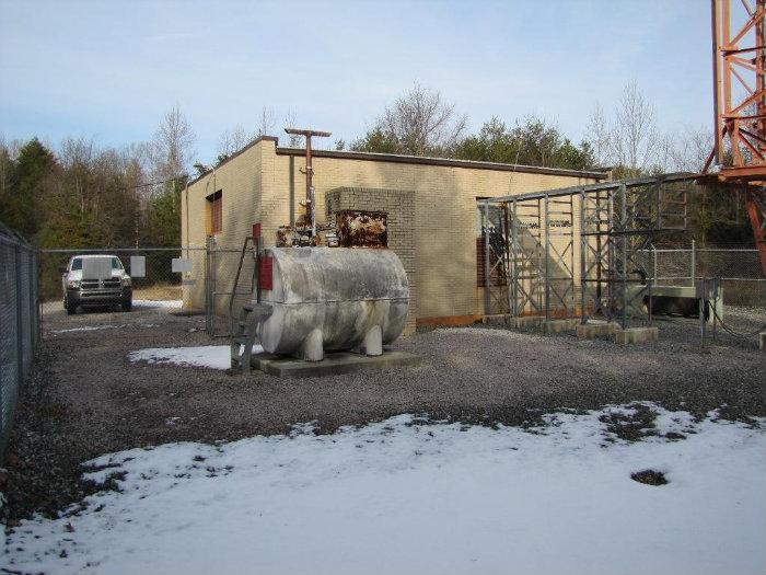
Utility Information
Telco Provider: Randolph Telephone Company
Power Provider: Duke Power
Backup Generator: Yes
www.americantower.com/SiteLocator/SiteBrochure.aspx?lng...
ftptower.americantower.com/SiteDocs2%5C1033%5CDrawings%...
ftptower.americantower.com/SiteDocs2%5C1033%5CDrawings%...
Address: LIBERTY RADIO TOWER 5010
City: Liberty
State: North Carolina
Zip Code: 27298-8159
Latitude:
Longitude:
35 - 54 - 2.49 N 35.901
79 - 34 - 41.08 W -79.578
maps.google.com/maps?q=35.901,%20-79.578
www.mapquest.com/?q=35.901,%20-79.578
Tower Data
Tower Number: 88641
Structure Height (AGL): 224 ft.
Structure Height (AMSL): 957 ft.
Clearance: 3 ft.
Total Height (AMSL): 960 ft.
Type: Guyed
FAA #: 2002-ASO-6410-OE
FCC #: 1008987
Site Specs
MTA: Charlotte-Greensboro-Greenville-Raleigh
BTA: Greensboro--Winston
MSA/RSA: Greensboro, NC
Ground Elevation AMSL: 733 ft.
Datum: NAD83
County: RANDOLPH
Region: USA
Comments:
Driving Instructions: From Hwy 64 in Siler City turn N. on SR 1004 (Martin Luther King Blvd).Go 5.4 miles to Crutch Field Crossroads and turn West on SR1346. Go 8.1 miles to Liberty ( will change from SR1346 to SR1301 @ the 4.5 miles mark). Go North on Sr 1006 for 3.5 miles and turn East on Richland Church Road. Go 1.4 miles and turn North on Kimesville Road and go 1.2 miles to Smith Wood Road. Turn Left and go .9 miles to Crowflight Road and turn Left . Go .8 miles to site, it's on the Right.
Utility Information
Telco Provider: Randolph Telephone Company
Power Provider: Duke Power
Backup Generator: Yes
www.americantower.com/SiteLocator/SiteBrochure.aspx?lng...
ftptower.americantower.com/SiteDocs2%5C1033%5CDrawings%...
ftptower.americantower.com/SiteDocs2%5C1033%5CDrawings%...
Nearby cities:
Coordinates: 35°54'3"N 79°34'42"W
- WUNC-TV/FM Tower 37 km
- Chapel Hill Capstar Radio Tower 38 km
- Former AT&T "Big Hole" Project Office 47 km
- WTOB-AM Radio Towers 72 km
- WSJS-AM 600 kHz Radio Towers 74 km
- WPTF AM Broadcast Towers 75 km
- Holston High Point Transmitter Array 238 km
- Pendergrass Nextel South Tower 415 km
- Transmitter Tower 443 km
- Ground Wave Emergency Network (GWEN) 462 km
- Greensburo Randolph Megasite 4.8 km
- Cane Creek Mountains 14 km
- Hagan-Stone Park 15 km
- Lake Mackintosh 16 km
- Cedar Falls 22 km
- Alamance County, North Carolina 23 km
- Lake Randleman 25 km
- Guilford County, North Carolina 27 km
- Randolph County, North Carolina 29 km
- Chatham County, North Carolina 39 km