Former RAF Knettishall
United Kingdom /
England /
East Harling /
World
/ United Kingdom
/ England
/ East Harling
World / United Kingdom / England
Second World War 1939-1945, abandoned / shut down, RAF - Royal Air Force, draw only border, Army Air Field US, historical layer / disappeared object, former air force base
USAAF Station 136
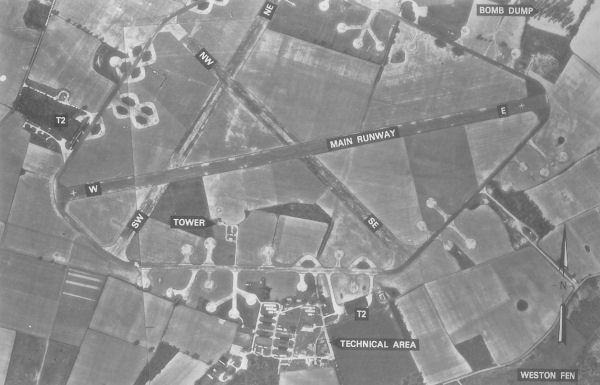
RAF Knettishall is a former World War II airfield in England. The field is located 6 miles SE of Thetford in Suffolk between the villages of Knettishall and Coney Weston, which lies to the south. Knettishall was built for United States Army Air Force Eighth Air Force use during 1942/1943 by W. & C. French Ltd. It was a late-design, heavy bomber airfield to Class A specification, and had the standard fifty-yard-wide concrete runways, the main being 6,000 feet long and the two intersecting secondary runways of 4,200 feet each in length, with an encircling perimeter track. There were fifty hardstands, two T2-type hangars and full technical services. Mark II airfield lighting permitted night flying.
Accommodation - largely Nissen huts - was provided in some dozen dispersed sites to the south of the flying airfield in the village of Coney Weston. The bomb store was situated on the far side of the field in a wood near Knettishall village.(use historical layer category to view)
USAAF use
Knettishall was one of several stations in East Anglia which was associated with a single Eighth Air Force unit for the whole of its operational period. It was assigned USAAF designation Station 136.
388th Bombardment Group (Heavy)
The airfield was opened on 10 June 1943 and was used by the USAAF 388th Bombardment Group (Heavy). The 388th arrived from Wendover AAF Utah and was assigned to the 45th Combat Bombardment Wing. Its group tail code was a "Square-H". Its operational squadrons were:
560th Bombardment Squadron
561st Bombardment Squadron
562d Bombardment Squadron
563d Bombardment Squadron
The group flew Boeing B-17 Flying Fortresses as part of the Eighth Air Force's strategic bombing campaign.
Post War
After the war, Knettishall was placed in the hands of a Royal Air Force holding group. Between 1946 and late 1948 it was used by the British Army as the base of the Depot Battalion, Royal Army Service Corps (RASC). The Depot Battalion was a transit organisation of the RASC for movements around the world. There was a permanent staff and always good cricket and football teams.The station was declared surplus to requirements on 22 February 1957 and was sold.
Civil use
With the end of military control, the runways and many of the buildings were broken up or demolished in the late 1950s.Today little is left visible of Knettishall airfield. A few single-lane farm roads are all that remains of the runways and taxiways, along with a handful of wartime buildings in various states of deterioration. An eight hundred metre grass airstrip has been constructed, adjacent to, and north of the line of the old east/west runway. Three small hangars house around six light aircraft. On a double loop hardstand to the west of the airfield three nissen-type huts and an old T-2 wartime hangar provides warehouse, storage and office space.
mighty8thaf.preller.us/php/1Unit.php?Unitkey=388
Wikipedia article: http://en.wikipedia.org/wiki/RAF_Knettishall
Nearby cities:
Coordinates: 52°22'35"N 0°53'22"E
- Châlons Vatry Airport 461 km
- Karup Airport/Air Base (KRP/EKKA) 688 km
- Air Base Bechyně 1012 km
- Zielona Góra Airport 1012 km
- Željava Air Base 1371 km
- Former military airfield in Uzyn 2069 km
- Onega Andozero Air Base 2497 km
- Vilne Air Base 2525 km
- Airfield Oktiabrske 2528 km
- Disbanded Bagerovo Air Base 2668 km
- Fakenham Wood 4.2 km
- Redgrave and Lopham Fen 8.2 km
- Military Zone 8.9 km
- RAF Honington 9 km
- Snetterton Motor Racing Circuit 11 km
- Former RAF Snetterton Heath 11 km
- RAF Barnham Camp 11 km
- Thetford Golf Club 13 km
- Thetford Rifle Range 14 km
- Stanford Training Area (StanTA) 17 km