Fort George (St. George's)
Bermuda /
Saint George /
St. George's
World
/ Bermuda
/ Saint George
/ Saint George
World / Bermuda
military, place with historical importance, fortification
British colonial fortifictation, built 1788-1840s, named for British King George III
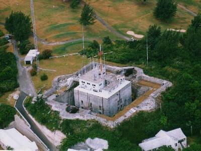
An eastern fort, on the North Shore in St. George's Parish, one of the many fortifications that ringed and protected the Town of St. George. Originally erected in 1612 to 1613 by Governor Moore as a single tower called Riches Mount, the fort recalls a bygone era of colonial militarism. In 1788, it was re-named Fort George after King George III in British defiance of the US War of Independence, and re-built. The present structure, which replaced the earlier redoubt by Andrew Durnford on the side of The Mount, dates partly back to 1788 and partly to the 1840's. This particular redoubt was built in the shape of an eight pointed star surrounded by an inner keep reached by drawbridges spanning a dry moat. Once manned night and day to keep away Britain's enemies, it even had an escape tunnel 150 feet long. The fort and its water catch are surrounded by cast iron fencing posts topped with a wired on crown or finial. The steep walk rewards visitors with a breath-taking view of the town and many islands of St. George's Harbor all the way over to St. David's Island. A 25 ton, 11 inch Rifled Muzzle Loader cannon is still aimed at cruise ships docked in the town of St. George.
Today, the fort serves an important civilian purpose. It is the headquarters of the Bermuda Maritime Operations Centre, owned and operated by the Bermuda Government under the Department of Marine & Ports Services. Several key functions are provided in support of the local and international maritime community. These include the role of Rescue Co-ordination Centre (RCC), Vessel Traffic Surveillance (VTS) and the all important communication functions associated with a Coast Radio Station (CRS).
The Bermuda Maritime Operations Centre maintains a 24 hour distress watch on the international distress frequencies of 2182 kHz, 4125kHz and VHF Channel 16 as well as the Global Maritime Distress and Safety System (GMDSS) Digital Selective Call (DSC) distress frequencies of 2187.5 kHz and VHF Channel 70. NAVTEX broadcasts are also undertaken on frequency 518 kHz with NAVTEX messages typically being received out to at least 300 miles of Bermuda. Notices to Mariners, Local Navigational Warnings, Atlantic and Bermuda marine weather forecasts are all broadcast around the clock according to an internationally published schedule. The service employs Radio Officers and RCC Controllers with their duties including watch keeping duties on a shift basis. On top of the keep is the Rescue Coordination Center (RCC) of Bermuda Harbor Radio, two specialty organizations. The Center has three main divisions in the area of ocean traffic: Rescue; Vessel Traffic Survey (VTS); and Harbor Radio, a Bermuda Government operated communication facility. Via the RCC, it provides a marine search and rescue service, vessel traffic services in the waters of Bermuda, a listening watch on marine distress frequencies, and marine communications services as required. It is microwave linked to a radar surveillance system on Gibb's Hill Lighthouse in Southampton Parish for all signals.
RCC Bermuda forms an integral part of a network of rescue centres around the world. Participation in an Inmarsat satellite alerting system called SARNet gives RCC's in Canada, Denmark, Greece, Norway, Spain, Finland and the United Kingdom the ability to broadcast information of common interest quickly and reliably. RCC Bermuda is the COSPAS-SARSAT Search and Rescue Point of Contact for Bermuda registered EPIRB or ELT alerts and with Bermuda registered ships and aircraft operating world-wide, SAR missions require a global outlook.
While the Bermuda Maritime Operations Centre (MOC) holds responsibility for the co-ordination of Search and Rescue (SAR) around the island generally, normally a rescue effort out to 30 miles from shore is all that can be undertaken on a consistent basis with the limited resources available locally. However in all SAR cases, best use of all available resources is essential and this typically will also lead to merchant vessels in transit through the Bermuda area being located and asked to divert to an incident position and U.S. Coast Guard aircraft support may also be requested. Through international maritime and aeronautical SAR agreements the United States holds ultimate responsibility for search and rescue in the Western Atlantic and Bermuda's geographic position mid-Atlantic lends itself nicely to the staging of rescue missions many hundreds of miles into the Atlantic.
Search and Rescue services in Bermuda are provided through the combined efforts of a number of Bermuda Government agencies. These include the Department of Marine and Ports Services, the Bermuda Police Marine Section and the Department of Agriculture and Fisheries. A variety of vessels suitable for work in both the shallow reef areas or the oceanic environment can be tasked as the need arises.
Nearby cities:
Coordinates: 32°22'49"N 64°40'57"W
- Fort St. Catherine 1.4 km
- Smith's fort 2.5 km
- Fort Popple 3.2 km
- St. David's (Great Head) Battery 3.4 km
- Devonshire Redoubt 4.5 km
- King's Castle Fort 4.5 km
- Fort Prospect 12 km
- Fort Hamilton 13 km
- Royal Naval Dockyard, Ireland Island 16 km
- Western and Southern Ramparts and Bastions (Royal Navy Dockyard) 16 km
- Five Forts Golf Club 0.5 km
- Town Cut 1.7 km
- Smith's Island 1.9 km
- L. F. Wade International Airport 2.1 km
- Annie's Bay 3.5 km
- Castle Harbour 3.5 km
- Cooper's island Nature Reserve 3.7 km
- Tucker's Point 5.2 km
- Tucker's Town 5.4 km
- Bermuda 11 km