Rezang-La Battle Field.
India /
Jammu and Kashmir /
Leh /
World
/ India
/ Jammu and Kashmir
/ Leh
World / India / Jammu and Kashmir / Ladakh (Leh)
battlefield, mountain pass
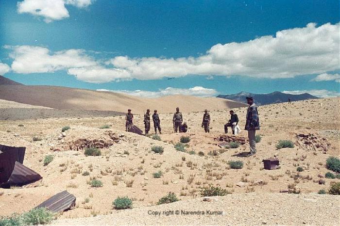
On routine patrolling of the Rezangla pass. In the photo you can see the actual battle field where the 13 Kumaon Regt soldiers fought against Chinese in the 1962 Indo-China war to the last man last round. Till recently the helmets of the soldiers were lying there but now it is taken by the 13 Kumaon. But the live mortars and shells with the bunkers are sill there. In the back ground you can see Trishul Heights (Mandong Ri)(Black coloured 3 point mountain).
Wikipedia article: http://en.wikipedia.org/wiki/Rezang_La
Nearby cities:
Coordinates: 33°25'13"N 78°51'49"E
- Battle of Asal Uttar 473 km
- Jhelum River - Battle of the Hydaspes River (325b.C.) 488 km
- Fight at Shaesta 861 km
- Longewala Attack Front 1063 km
- Battle Field of Challakere-Dodderi Battle 2123 km
- Iran-Iraq War Battlefield 2859 km
- Shalamcheh 2919 km
- Area of phosphorus weapons usage by the Azerbaijani army in October 2020 2935 km
- Majnoon Oilfield Development 2950 km
- Heyvaly 2956 km
- PLA Installation 12 km
- Spangur Lake 14 km
- Spanggur Gap, India. 18 km
- Changthang Wildlife Sanctuary 25 km
- Frozen Indus 33 km
- Finger 3-4 Indian Territory 37 km
- Pangong Lake, Indian Side 39 km
- Pangong Lake 47 km
- Shaldat Tsho 48 km
- Zumunang Lake 54 km
Comments