Wroxeter Roman City
United Kingdom /
England /
Shawbury /
World
/ United Kingdom
/ England
/ Shawbury
World / United Kingdom / England
ruins, archaeological site, Roman Empire, abandoned settlement, English Heritage
Wroxeter Roman City is the name of an abandoned Roman city which was actually named "Viroconium" (but is now known as "Wroxeter Roman City").
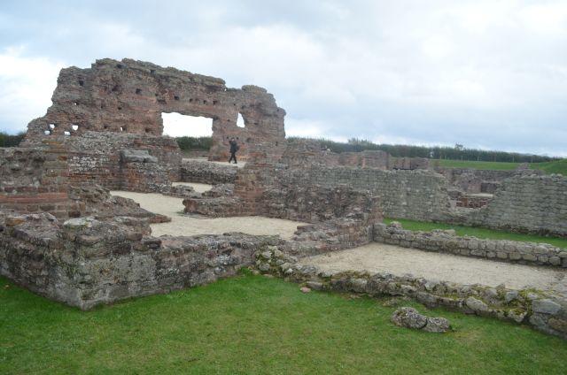
Viroconium is estimated to have been the fourth largest Roman settlement in Britain with a population of more than 6,000 people at its peak. It was founded in the later 1st century AD and by 130 had grown to cover an area of more than 70 ha and contained baths and a forum dedicated to the emperor Hadrian.
Although in decline, the city continued to be occupied following the Roman withdrawal in AD 410 and (like many places in England) has been suggested to be the original Camelot of Arthurian legend.
Impressive standing remains have been excavated, including an archway that is the largest free-standing Roman ruin in England. Most of the city remains underground, but it has been mapped through geophysical survey and aerial archaeology.
Wikipedia article: https://en.wikipedia.org/wiki/Viroconium_Cornoviorum
Nearby cities:
Coordinates: 52°40'29"N 2°38'36"W
- Stafford Castle 36 km
- Dudley Priory (Park & Ruins) 41 km
- Former POW Camp 93 km
- Butterley Tunnel (Derelict) 93 km
- Roman Fort 161 km
- Chapel House Wood Settlement 162 km
- Dacre Top Barrows and Settlement 163 km
- Site of Priory (Gilbertine) 167 km
- Kirkstead Abbey 170 km
- Remains of Revesby Cistercian Abbey 180 km
- Attingham Park 2 km
- Longner Hall Estate 3.7 km
- Tarmac Ltd Sharpstone Quarry 7 km
- Condover Quarry 7 km
- RAF Condover (Disused) 7.3 km
- Park Wood 7.8 km
- Meole Brace 8.2 km
- Shrewsbury Golf Club 8.5 km
- Wenlock Edge 17 km
- Shropshire Hills AONB 23 km