Direction Island
External Territories (Australia) /
Cocos Islands /
Bantam /
World
/ External Territories (Australia)
/ Cocos Islands
/ Bantam
World
island, battlefield
Direction Island (Malay name Pulu Tikus) is in the South Keeling Atoll, Cocos Islands.
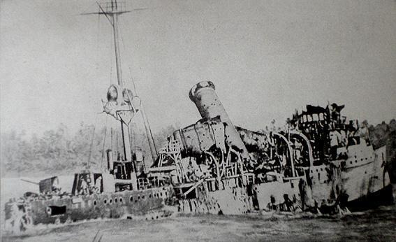
Location of "Battle of Cocos" on 9 November 1914 during World War I between German cruiser SMS Emden und the Australian cruiser HMAS Sydney, see:
en.wikipedia.org/wiki/Battle_of_Cocos
Location of "Battle of Cocos" on 9 November 1914 during World War I between German cruiser SMS Emden und the Australian cruiser HMAS Sydney, see:
en.wikipedia.org/wiki/Battle_of_Cocos
Nearby cities:
Coordinates: 12°5'26"S 96°52'57"E
- Pulau Selma 1.9 km
- Pulau Cheplok 5.8 km
- Pulau Luar 5.9 km
- Pulu Pandan 6.9 km
- Pulu Siput 7.6 km
- South Island (Pulau Atas) 7.6 km
- Pulau Panjang 8.6 km
- Pulu Kambing 12 km
- North Keeling Island 31 km
- Cocos (Keeling) Islands 31 km
- Port Refuge 1.6 km
- Western Entrance 6.8 km
- North Lagoon 11 km
- Old Quarantine Station 11 km
- Telok Geronjeng 11 km
- Runway 15/33 12 km
- Cocos Island Airport (ICAO: YPCC / IATA: CCK) 12 km
- Telok Semberang 12 km
- South Lagoon 13 km
- Pulu Keeling National Park 30 km