Similipal National Park
India /
Orissa /
Udala /
World
/ India
/ Orissa
/ Udala
World / India / Orissa / Mayurbhanj
mountain, forest, national park


By Road - Baripada, the district headquarters of Mayurbhanj, on the junction of NH 5 and 6, is 170 km from Bhubaneswar, 240 from Kolkata and 60 km from Balasore and 22 km from Pithabata, which is an entry point. The other entry point Jashipur is 94 km from Baripada on N.H. 6. Both the places are well connected by regular bus services. Taxis and Jeeps are available.By Rail - Nearest railhead is Balasore (60 km from Baripada), served by major trains running on the South-Eastern sector.By Air - Nearest airports are Bhubaneswar (270 kms) and Kolkata (240 km) Direct drive down from Kolkata is preferable.
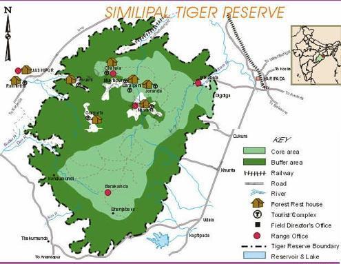
Simlipal National Park is a national park and a Tiger Reserve situated in the Mayurbhanj district in the Indian state of Orissa.
Simlipal National Park derives its name from the magnificent Simul (Silk Cotton Tree) tree.
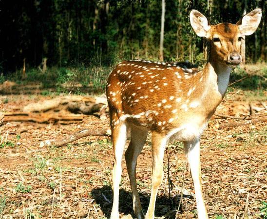
The park has an area of 845.70 sq km and has some beautiful waterfalls like Joranda and Barehipani. The park is famous for its tigers, leopards and elephants, hill maynah and orchids.
Simlipal National Park is a national park and a Tiger Reserve situated in the Mayurbhanj district in the Indian state of Orissa.
Simlipal National Park derives its name from the magnificent Simul (Silk Cotton Tree) tree.
The park has an area of 845.70 sq km and has some beautiful waterfalls like Joranda and Barehipani. The park is famous for its tigers, leopards and elephants, hill maynah and orchids.
Wikipedia article: http://en.wikipedia.org/wiki/Simlipal_National_Park
Nearby cities:
Coordinates: 21°46'33"N 86°20'48"E
- Kuldiha Wildlife Sanctuary, Nilgiri 32 km
- Nilgiri Hillock 49 km
- Gandhamardan Iron Or Project,Suakati,Kendujhar 90 km
- Badkera Pahad 183 km
- Kasakenda Parbat 205 km
- RAJ SUNAKHALA HILLS 217 km
- Mani Naga Range 222 km
- Nayagarh-Odagaon-Sulia Range 232 km
- Bhaleri Hills 257 km
- Mahendra Giri (Hills) 370 km
- BHADAR GHORA 2.6 km
- Jamunagarh vill, SBR 7.6 km
- Kabatghai vill, SBR 8.7 km
- Astakumar 11 km
- Source of West Deo River 13 km
- NUNIA GODA VILLAGE 16 km
- HALDIA VILLAGE 18 km
- Budhigaon 18 km
- Deo Irrigation Project Area 23 km
- Bhajam hill 24 km
Comments