Kuliarchar Upazila HQ
Bangladesh /
Kishorganj /
Bajitpur /
World
/ Bangladesh
/ Kishorganj
/ Bajitpur
World / Bangladesh / Dhaka / Kishoreganj / Kishoreganj
township, subdistrict, fourth-level administrative division, local government
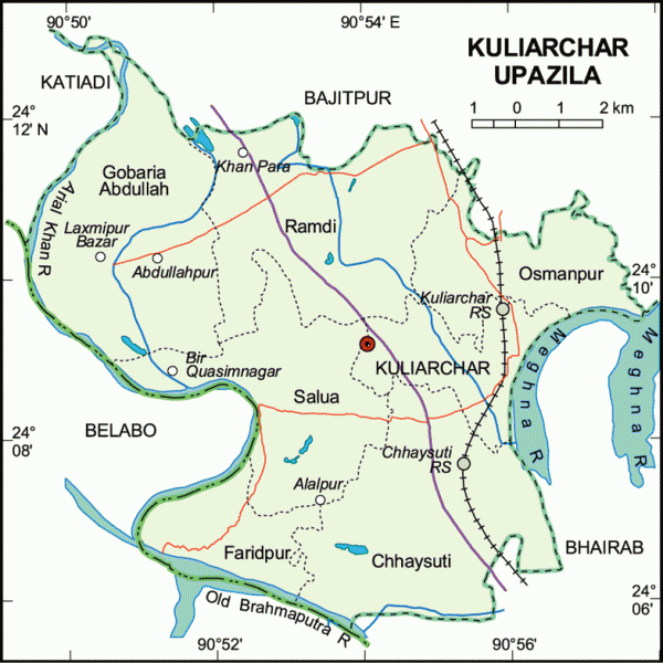
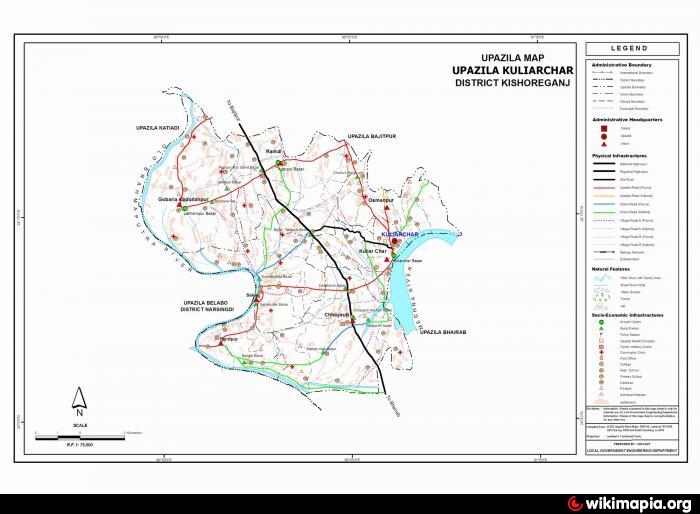
Kuliarchar Upazila (Kishoreganj district) with an area of 104.01 sq km, is bounded by Bajitpur upazila on the north, Belabo and Bhairab upazilas on the south, Bhairab and Bajitpur upazilas on the east, Katiadi and Belabo upazilas on the west. Main rivers: Meghna, old Brahmaputra and Arial khan; Beel 5.
Kuliarchar (Town) consists of 9 wards and 37 mahallas. It has an area of 3.45 sq km and a population of 28027; male 50.65%, female 49.35%; density of population is 8124 per sq km. Literacy rate among the town people is 28.8%.
Kuliarchar thana was established in 1921 and was turned into an upazila in 1984. The upazila consists of one municipality, 9 wards, 7 union parishads, 46 mouzas and 131 villages.
As of the 1991 Bangladesh census: Population 133327; male 50.61%, female 49.39%.
Religious institutions: Mosque 210, temple 16, sacred place 1.
Literacy and educational institutions: Average literacy 21.6%; male 26.9% and female 16%. Educational institutions: college 1, high school 9, junior high school 1, madrasa 10, government primary school 55, non-government primary school 14; noted institutions: Kishoreganj Gurudayal College (1943), Government Mohila College (1969).
Cultural organisations: Club 45, cinema hall 2, co-operative society 189.
Main occupations: Agriculture 51.54%, fishing 1.88%, agricultural labourer 15.66%, wage labourer 2.39%, transport 1.93%, commerce 12.15%, service 4.37%, others 10.08%.
Land use: Total cultivable land 8470 hectares, fallow land 819 hectares; single crop 7.68%, double crop 82.10% and treble crop 10.22%; land under irrigation 3239 hectares.
Land control: Among the peasants, 22.38% are landless, 22.71% marginal, 35.54% small, 28.29% intermediate and 1.08% rich.
Communication facilities- Roads: pucca 30 km and mud road 501 km; railways 11 km.
Manufactories: Cold storage 1, chess production mill 1, ice factory 9, feed mill 1 and oil mill 1.
Cottage industries: Bamboo work 20, goldsmith 115, blacksmith 102, potteries 60, brass work 10 and cotton work 120.
NGO activities: Operationally important NGOs are brac, asa, proshika, Usa, Daus and Global Village.
Health centres: Upazila health complex 1, family planning centre 5, rural health centre 4 and veterinary hospital 1
Nearby cities:
Coordinates: 24°8'57"N 90°55'30"E
- Rupganj Upazila 44 km
- Kapashia Upazila 47 km
- Gafargaon Upazila 65 km
- Matlab Upazila (North) Area 80 km
- Keraniganj Upazila 82 km
- Lohajang Upazila 98 km
- Dhobaura Upazila 131 km
- Patiya Upazila (পটিয়া) 219 km
- Chandanaish Upazila 233 km
- Banshkhali Upazila (বাঁশখালী উপজেলা) 238 km
- Horse Shoe Lake 2.8 km
- Noagaon, Chhaysuti, Kuliar Char, Kishoregonj-2341 4.8 km
- Confluence of the two rivers Surma and Kushiara giving rise to the Meghna River 7.1 km
- Sarrabad Village, Belabo, Narsingdi 8.9 km
- parmananda pur village 12 km
- Fatepur village 12 km
- Kalipur 12 km
- Bhairab Bazaar 13 km
- Confluence 14 km
- Narsingdi District 21 km