Brahmanbaria District City
Bangladesh /
Brahman Bariya /
World
/ Bangladesh
/ Brahman Bariya
/ Brahman Bariya
World / Bangladesh / Chittagong / Comilla / Brahmanbaria
second-level administrative division, city district
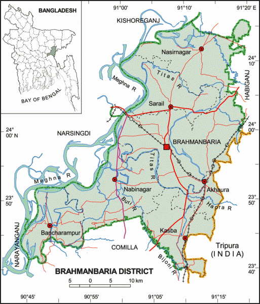
Brahmanbaria District (Chittagong division) with an area of 1927.11 sq km, is bounded by Kishoreganj and Habiganj district on the north, Comilla district on the south, Hobiganj district and Tripura State of India on the east and Meghna river, Kishoreganj, Narsingdi and Narayanganj districts on the west. The district is a lowlying land having small hills and hillocks of red soil. Annual highest average temperature 34.3°C and lowest 12.7°C; Annual total rain fall is 2551 mm. Main rivers are Meghna and Titas, Buri and Haora; Mehedi and Akashi haors are notable.
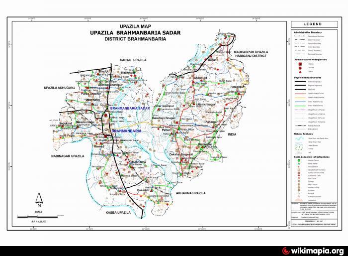
The location of Brahmanbaria town centre is 23.9690242N 91.1059284E. Brahmanbaria (Town) consists of 12 wards and 46 mahallas. The area of the town is 30.82 sq km. It has a population of 131334; male 51.34%, female 48.66%. Literacy rate among the town people is 52.3%. Brahmanbaria town began to grow from the nineteenth century. The town was turned into a municipality in 1869. The tomb of Hazrat Syed Kazi Mahmud Shah (R) is located at Kazipara of the town. During the invasion of Munipur by the British in 1824. Brahmanbaria town was their military headquarters. The main business centres of the town are Ananda Bazar and Tanbazar. Other notable areas of the town are Jagatbazar, Mahabedab Patti, Kalaishreepara, Madhyapara, Kazipara and Kandhipara.
Brahmanbaria has a rich tradition of nurturing art, education and culture. Ustad Allauddin Khan, the great musical talent of the subcontinent and the father of 'Maihar Gharana' of classical Indian music, was born in this district in 1862. Besides, Ustad Fakir (Tapas) Aftab Uddin Khan, Ustad Alauddin Khan, Ustad Ayet Ali Khan, Ustad Ali Akbar Khan, Ustad Bahadur Hussain Khan, Ustad Abed Hussain Khan, Ustad Khadem Hussain Khan are illustrios sons in the field of music. Al Mahmud is one of the leading poets of modern Bengali. During the 19th century, Brahmanbaria produced great nationalist leaders like Nawab Syed Shamsul Huda, who became president of All India Muslim League in 1921, and Barrister Abdur Rasul.
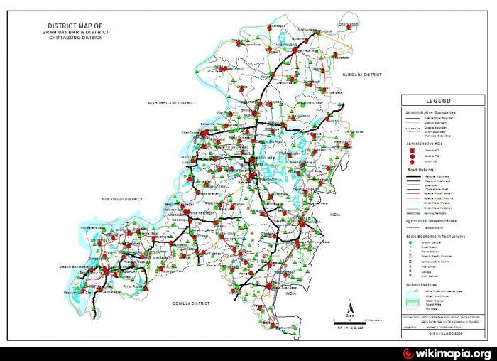
Brahmanbaria district, which was included in Comilla district (formerly Tipera district) was established in 1984. Before 1830 the Sarail Pargana was a part of Mymensingh district. The district has 4 municipalities, 39 wards, 97 mahallas, 7 upazilas, one thana, 98 union parishads, 1052 mouzas and 1329 villages. The upazilas are banchharampur, kasba, nabinagar, nasirnagar, brahmanbaria sadar, sarail and akhaura.
Archaeological heritage and relics: Arphail Sagardighi Mosque and Twin Graves (sixteenth century, Sarail), Arphannesa Mosque (1662, Sarail), Bhadurghar Shahi Mosque (1084 AH), Ulchapara Mosque (sixteenth century), tomb of Kalla Shahid (Akhaura), Kalbhairab Mandir (Brahmanbaria), Anandamoye Ashram (seventeenth century) at Kasba, Bishnu Statue (Baghaura), buddhist viharas (Devgram).
Historical events: Brahmanbaria was a part of samatata Janapada of the ancient Bengal. The first and temporary capital of Isa khan was at Sarail 10 km on the north of Brahmanbaria Town.
As of the 1991 Bangladesh census, population 2365880; male 49.49%, female 50.51%; Muslim 90.73%, Hindu 9.07%, Buddhist 0.05%, Christian 0.04% and others 0.11%.
Religious institutions: Mosque 1987, temple 134, church 2, tomb 30 and sacred places 5.
Literacy and educational institutions: Average literacy 26.6%; male 32.7% and female 20.3%. Educational institutions: government college 2, non-government college 27, homeopath college 1, law college 1, government high school 7, non-government high school 144, junior high school 44, madrasa 78, government primary school 690, non-government primary school 323, nursing institute 1, primary training institute 1, deaf and damp school 1, blind school 1, industrial school 1, vocational training institute 2, textile engineering and technology school 1, community school 4, music school 4 and satellite school 14. Noted educational institution: Brahmanbaria Government College (1948), Brahmanbaria Annada Government High School (1875), Government Model Girl's High School (1936), Ramkanai Jamia Islamia Younusia Madrasa (1334 AH), Debgram Pilot High School (1905, Akhaura), Bangladesh Railway Government High School (1920), Kasba Government High School (1899), Kuti Atalbihari High School (1918), Nabinagar Pilot High School (1896), Phandauk PR High School (1938, Nasirnagar), Sarail Annada Government High School (1893), Chunta AC Academy (Sarail).
Cultural organisations: Club 89, public library 9, cinema hall 16, womem's organisation 80, community centre 8, Shilpakala Academy 1, Shishu Academy 1, Museum 1, theatre stage 1, theatre group 8, opera party (extinct) 20, circus party 1, puppet-show party 10, literary society 20, cooperative society 832 and playground 85. Noted cultural organisations: BGFC Officers' Club, Brahmanbaria Public Library, Brahmanbaria Archives Museum, Town Hall (Ustad Alauddin Khan Municipal Auditorium), Royal Star Circus, Royal Bina Opera, Sahitya Academy; extinct- Lalmohan Library, Swashwata Brahmo-Samaj, Kalyan Sangha (revolutionary organisation), Pabitra Sangha and Sarail-Kalikaschha Club.
Main occupations: Agriculture 44.79%, agricultural labourer 15.82%, wage labourer 3.13%, commerce 12.26%, service 6.8%, fishing 2.02% and transport 1.85%, weaving 2.39% and others 10.94%.
Land use: Total cultivable land 152280 hectares; fallow land 700 hectares; single crop 28.38%, double crop 53.95% and treble crop land 17.67%; land under irrigation 55.31%.
Land control: Among the peasants 11% are landless, 61% small, 24% intermediate and 4% rich; cultivable land per head 0.07 hectare.
Main crops: Paddy, jute, wheat, mustard seed, potato, onion, garlic, chilli, pulses, brinjal, kakrol and patal. Kakrol produced in Mukundopur of this district deserves special mention.
Fisheries, dairies, poultries Poultry 83, fishery 64, dairy 61, hatchery 43, nursery 17 and artificial breeding centre 1.
Communication facilities- Roads: pucca 266 km, semi pucca 86 km and mud road 1629 km; waterways 131 nautical mile; railways 71km.
Cottage industries: Brahmanbaria district is famous for the production of cotton fabrics. In the nineteenth century Tanjeb, fine quality muslin, used to be produced in Sarail. Hats, made of cane, are being produced at Radhika from the British period. Brahmanbaria has a rich tradition of boat race, boats are being made at Champanagar. Other cottage industries include weaving, such bamboo work, cane work, handicraft, goldsmith, blacksmith, wood work, potteries and tailoring.
Manufactories: Fertiliser factory, flour mill, rice mill, ice factory, oil mill, saw mill, welding, etc.
Mineral resources Natural gas; gas field 3 (Titas Gas, Meghna Gas Field and Saldandi Gas Field).
NGO activities: Operationally important NGOs are asa, brac, CARE, grameen bank, proshika, Save the Children, Social Marketing Company, IDE, VDC, Ujjiban Kendra, Gana Kalyan Kendra.
Health centres: Zila Sadar Hospital 1, upazila health complex 8, health and family planning centre 79, maternity and child welfare centre 2, TB hospital 1, diabetics hospital 1, police hospital 1, prison hospital 1, mission hospital 1, palli health centre 2, satellite clinic 13.
The location of Brahmanbaria town centre is 23.9690242N 91.1059284E. Brahmanbaria (Town) consists of 12 wards and 46 mahallas. The area of the town is 30.82 sq km. It has a population of 131334; male 51.34%, female 48.66%. Literacy rate among the town people is 52.3%. Brahmanbaria town began to grow from the nineteenth century. The town was turned into a municipality in 1869. The tomb of Hazrat Syed Kazi Mahmud Shah (R) is located at Kazipara of the town. During the invasion of Munipur by the British in 1824. Brahmanbaria town was their military headquarters. The main business centres of the town are Ananda Bazar and Tanbazar. Other notable areas of the town are Jagatbazar, Mahabedab Patti, Kalaishreepara, Madhyapara, Kazipara and Kandhipara.
Brahmanbaria has a rich tradition of nurturing art, education and culture. Ustad Allauddin Khan, the great musical talent of the subcontinent and the father of 'Maihar Gharana' of classical Indian music, was born in this district in 1862. Besides, Ustad Fakir (Tapas) Aftab Uddin Khan, Ustad Alauddin Khan, Ustad Ayet Ali Khan, Ustad Ali Akbar Khan, Ustad Bahadur Hussain Khan, Ustad Abed Hussain Khan, Ustad Khadem Hussain Khan are illustrios sons in the field of music. Al Mahmud is one of the leading poets of modern Bengali. During the 19th century, Brahmanbaria produced great nationalist leaders like Nawab Syed Shamsul Huda, who became president of All India Muslim League in 1921, and Barrister Abdur Rasul.
Brahmanbaria district, which was included in Comilla district (formerly Tipera district) was established in 1984. Before 1830 the Sarail Pargana was a part of Mymensingh district. The district has 4 municipalities, 39 wards, 97 mahallas, 7 upazilas, one thana, 98 union parishads, 1052 mouzas and 1329 villages. The upazilas are banchharampur, kasba, nabinagar, nasirnagar, brahmanbaria sadar, sarail and akhaura.
Archaeological heritage and relics: Arphail Sagardighi Mosque and Twin Graves (sixteenth century, Sarail), Arphannesa Mosque (1662, Sarail), Bhadurghar Shahi Mosque (1084 AH), Ulchapara Mosque (sixteenth century), tomb of Kalla Shahid (Akhaura), Kalbhairab Mandir (Brahmanbaria), Anandamoye Ashram (seventeenth century) at Kasba, Bishnu Statue (Baghaura), buddhist viharas (Devgram).
Historical events: Brahmanbaria was a part of samatata Janapada of the ancient Bengal. The first and temporary capital of Isa khan was at Sarail 10 km on the north of Brahmanbaria Town.
As of the 1991 Bangladesh census, population 2365880; male 49.49%, female 50.51%; Muslim 90.73%, Hindu 9.07%, Buddhist 0.05%, Christian 0.04% and others 0.11%.
Religious institutions: Mosque 1987, temple 134, church 2, tomb 30 and sacred places 5.
Literacy and educational institutions: Average literacy 26.6%; male 32.7% and female 20.3%. Educational institutions: government college 2, non-government college 27, homeopath college 1, law college 1, government high school 7, non-government high school 144, junior high school 44, madrasa 78, government primary school 690, non-government primary school 323, nursing institute 1, primary training institute 1, deaf and damp school 1, blind school 1, industrial school 1, vocational training institute 2, textile engineering and technology school 1, community school 4, music school 4 and satellite school 14. Noted educational institution: Brahmanbaria Government College (1948), Brahmanbaria Annada Government High School (1875), Government Model Girl's High School (1936), Ramkanai Jamia Islamia Younusia Madrasa (1334 AH), Debgram Pilot High School (1905, Akhaura), Bangladesh Railway Government High School (1920), Kasba Government High School (1899), Kuti Atalbihari High School (1918), Nabinagar Pilot High School (1896), Phandauk PR High School (1938, Nasirnagar), Sarail Annada Government High School (1893), Chunta AC Academy (Sarail).
Cultural organisations: Club 89, public library 9, cinema hall 16, womem's organisation 80, community centre 8, Shilpakala Academy 1, Shishu Academy 1, Museum 1, theatre stage 1, theatre group 8, opera party (extinct) 20, circus party 1, puppet-show party 10, literary society 20, cooperative society 832 and playground 85. Noted cultural organisations: BGFC Officers' Club, Brahmanbaria Public Library, Brahmanbaria Archives Museum, Town Hall (Ustad Alauddin Khan Municipal Auditorium), Royal Star Circus, Royal Bina Opera, Sahitya Academy; extinct- Lalmohan Library, Swashwata Brahmo-Samaj, Kalyan Sangha (revolutionary organisation), Pabitra Sangha and Sarail-Kalikaschha Club.
Main occupations: Agriculture 44.79%, agricultural labourer 15.82%, wage labourer 3.13%, commerce 12.26%, service 6.8%, fishing 2.02% and transport 1.85%, weaving 2.39% and others 10.94%.
Land use: Total cultivable land 152280 hectares; fallow land 700 hectares; single crop 28.38%, double crop 53.95% and treble crop land 17.67%; land under irrigation 55.31%.
Land control: Among the peasants 11% are landless, 61% small, 24% intermediate and 4% rich; cultivable land per head 0.07 hectare.
Main crops: Paddy, jute, wheat, mustard seed, potato, onion, garlic, chilli, pulses, brinjal, kakrol and patal. Kakrol produced in Mukundopur of this district deserves special mention.
Fisheries, dairies, poultries Poultry 83, fishery 64, dairy 61, hatchery 43, nursery 17 and artificial breeding centre 1.
Communication facilities- Roads: pucca 266 km, semi pucca 86 km and mud road 1629 km; waterways 131 nautical mile; railways 71km.
Cottage industries: Brahmanbaria district is famous for the production of cotton fabrics. In the nineteenth century Tanjeb, fine quality muslin, used to be produced in Sarail. Hats, made of cane, are being produced at Radhika from the British period. Brahmanbaria has a rich tradition of boat race, boats are being made at Champanagar. Other cottage industries include weaving, such bamboo work, cane work, handicraft, goldsmith, blacksmith, wood work, potteries and tailoring.
Manufactories: Fertiliser factory, flour mill, rice mill, ice factory, oil mill, saw mill, welding, etc.
Mineral resources Natural gas; gas field 3 (Titas Gas, Meghna Gas Field and Saldandi Gas Field).
NGO activities: Operationally important NGOs are asa, brac, CARE, grameen bank, proshika, Save the Children, Social Marketing Company, IDE, VDC, Ujjiban Kendra, Gana Kalyan Kendra.
Health centres: Zila Sadar Hospital 1, upazila health complex 8, health and family planning centre 79, maternity and child welfare centre 2, TB hospital 1, diabetics hospital 1, police hospital 1, prison hospital 1, mission hospital 1, palli health centre 2, satellite clinic 13.
Nearby cities:
Coordinates: 23°58'14"N 91°6'29"E
- Narsingdi District 64 km
- Lakhsmipur Dist Town 115 km
- Mymensingh District Town 118 km
- Noakhali District Town 121 km
- Khagrachari District Town 125 km
- Bhola District Town 149 km
- Rangamati Dist Town 176 km
- Lunglei 200 km
- Golaghat 405 km
- Chenggong 1190 km
- Civic Zone 1.6 km
- East Medda 2 km
- korilla khal, excavated by AZM Obaidullah Khan the then commisioner Chittagong Division 2 km
- Brahmanbaria District Jail 5.9 km
- BSCIC- Brahmanbaria 7.5 km
- Agartala Airport 16 km
- Habigonj District 56 km
- Tripura 77 km
- Dhaka Division 80 km
- Sylhet Division 94 km
Comments