Barura Upazila HQ
Bangladesh /
Komilla /
World
/ Bangladesh
/ Komilla
/ Komilla
World / Bangladesh / Chittagong / Comilla / Comilla
township, subdistrict, fourth-level administrative division, local government
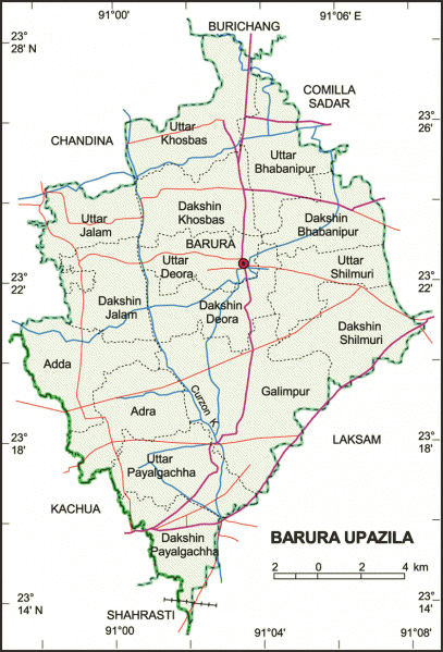
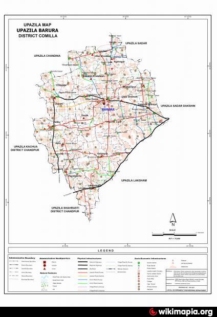
Barura Upazila (Comilla district) with an area of 241.65 sq km, is bounded by Burichang and Chandina upazilas on the north, Laksam upazila on the south, Comilla sadar upazila on the east and Chandina and Kachua upazilas on the west. Part of Lalmai Hills stand on the eastern side of the upazila. Carzon khal is notable
The location of Barura town is 23.3751288N 91.0507647E. Barura (Town) The town is now a municipality with an area of about 4.87 sq km. It consists of 9 wards and 26 mahallas. The town has a population of 38608; male 49.76%, female 50.24%. Literacy rate among the town people is 35.7%. There is a big pond known as Krishna Sagar located in the upazila sadar.
Barura thana was established in 1948 and was turned into an upazila in 1983. Earlier Barura thana was a part of the Chandina thana. Barura municipality was established in 1995. The upazila consists of one municipality, 15 union parishads, 231 mouzas and 332 villages.
Archaeological heritage and relics: Adinamura Mosque and Mazar.
As of the 1991 Bangladesh census: Population 310778; male 50.05%, female 49.95%; Muslim 91.37%, Hindu 8.44%, Buddhist 0.14%, and others 0.05%. Population density per sq km is 1284.
Religious institutions: Mosque 499, temple 98, buddhist vihara 1, Eidgah 134. Noted religious institutions Barura Jami Mosque, Adinamura Mosque and Mazar, tomb of Abdul Hamid (R) at Maheshpur, Barura Central Eidgah and Chandimata Mandir at Chandimura.
Literacy and educational institutions: Average literacy 31.8%; male 37.6% and female 26%. Educational institutions: college 3, high school 35, junior high school 3, madrasa 35, maktab 300, government primary school 97, non-government primary school 23 and low cost school 15. Noted educational institutions: Barura Shahid Smriti Government College (1972), Payalgachha Post Graduate College, Barura Hazi Nawab Ali Pilot High School (1967), Talagram T C Laha Multilateral High School (1931), Rajamara Sunnia Madrassa (1944), Barura Alia Madrassa.
Cultural organisations: Club 42, public library 2, theatre party 1, cooperative society 218, community centre 16.
Main occupations: Agriculture 53.28%, agricultural labour 18.88%, wage labourer 2.22%, commerce 7.96%, service 6.31%, transport 3.26%, and others 8.09%.
Land use: Total cultivable land 18020.64 hectares single crop 6.73%, double crop 62.74% and treble crop land 30.53%; cultivable land under irrigation 9337.92 hectares.
Land control: Among the peasants 22% are landless, 29% small, 38% intermediate and 11% rich.
Fisheries, dairies, poultries farm Dairy 35, poultry 46.
Communication facilities- Roads: pucca road 61 km, semi pucca 10 km and mud road 982 km; railways 0.25 km.
Manufactories: Rice mill 1, brick field 4, cotton mill 1.
Cottage industries: Loom 129, bamboo and cane work 746, hogla leaf work 41, jute and wood work 173.
NGO activities: Operationally important NGOs are brac, asa, grameen bank, Care, proshika, Pages and Health Care Clinic.
Health centres: Upazila health complex 1, family planning centre 14, satellite clinic 5, private clinic 1 and charitable dispensary 5.
Nearby cities:
Coordinates: 23°22'22"N 91°3'40"E
- Matlab Upazila (North) Area 52 km
- Rupganj Upazila 84 km
- Lohajang Upazila 87 km
- Keraniganj Upazila 93 km
- Kapashia Upazila 116 km
- Patiya Upazila (পটিয়া) 136 km
- Gafargaon Upazila 144 km
- Chandanaish Upazila 152 km
- Banshkhali Upazila (বাঁশখালী উপজেলা) 155 km
- Dhobaura Upazila 216 km
- Lalmai Hills 7.8 km
- Nurpur Amit Singha House 9 km
- laksam mr. k hassan home, laksam mr.k hassan home 10 km
- hoila jola 11 km
- village: iruain (mithu) 15 km
- Nolchowa 15 km
- Jugir Kandee 16 km
- KASHI NAGAR OLI PUR 17 km
- Parbain Zilani Home 18 km
- Tripura 89 km