Beanibazar Upazila HQ
| township, subdistrict, fourth-level administrative division, local government
India /
Assam /
Karimganj /
World
/ India
/ Assam
/ Karimganj
World / Bangladesh / Sylhet / Sylhet / Sylhet
township, subdistrict, fourth-level administrative division, local government

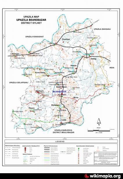
Beanibazar Upazila (Sylhet district) with an area of 253.22 sq km is bounded by Kanaighat and Zakiganj upazilas on the north, Barlekha on the south, Assam (India) and Zakiganj upaizila on the east and Golabganj upazila on the west. The upazila has 12.01 km long international boundary with India. Main rivers: surma, Kushiyara and Sonai. Main canals: Kalauchi and Sada Khal; haor 1; Jalmahal 43; total forest area 15.54 sq km; tilas (hillocks) 170.
Beanibazar town is located at 24.8177965N 92.1574003E. Beanibazar (Town) consists of 5 mouzas. The town has an area of 7.28 sq km. It has a population of 14009; male 51.02%, female 48.98%; density of population is 1924 per sq km. Literacy rate among the town people is 56.9%. The town has one rest house.
Beanibazar thana was established in 1938 and was turned into an upazila in 1983. The upazila consists of 11 union parishads, 145 mouzas and 176 villages.
Archaeological heritage Basudeva Temole and Basudeva image (made of black basalt) at Supatala mouza, copperplate inscription and an elephant embossed stamp of the Kamarupa king Vaskar Barma, remnants of the palace of Tengra.
Historical events: The region was once inhabited by the tribal Kukis.
As of 1991 Bangladesh census, Population 181547; male 49.50%, female 50.50%; Muslim 95.66%, Hindu 4.31%, and others 0.03%.
Religious institutions Mosque 388, temple 19, sacred place 1 and tomb 7, noted of which are Patan Baghmara Jami Masjid, tomb of Golab Shah (Bashba) known as 'Imam Bari', Mahapravhu Bigraha Akhra (Jaldhup).
Literacy and educational institutions Average literacy 61.3%; male 66.3%, female 56.3%. Educational institutions: college 6, secondary school 31, junior high school 2, primary school (government) 113, primary school (non-government) 19, satellite school 10, kindergarten 4, madrasa 45. Lautah High School (1871), Khasa Government Primary School (1895), Jaldhup Government Primary School (1909), Panchakanda Hargovinda High School (1917) are notable educational institutions.
Main occupations Agriculture 19.33%, fishing 4.52%, agricultural labourer 10.15%, wage labourer 8.6%, commerce 11.87%, transport 2.11%, construction 2.61%, service 5.04%, house renting out 14.57%, others 21.2%.
Land use Arable land 22783.08 hectares, fallow land 2244.03 hectares; single crop 64%, double crop 30% and triple crop 6%. Cultivable land under irrigation 476.73 hectares.
Land control Among the peasants 10% are landless, 75% marginal, 12% intermediate and 3% rich; cultivable land per head 0.15 hectare.
Fisheries, dairies, poultries Fishery 48, dairy 5, poultry 43.
Communication facilities Roads: pucca 57 km, semi pucca 20 km and mud road 209 km.
Manufactories Ice cream factory 21, rice mill 55, saw mill 25.
Cottage industries Bamboo works 10, goldsmith 50, blacksmith 40, potteries 10, wood works 94, tailoring 201, welding 41, wool knitting 5, leather works 1, pottery 1.
Mineral resources Gas field 2.
Main exports Orange, cassia leaf, gas.
NGO activities CARE, brac, asa, and Symantik (local).
Health centres Upazila health centre 1, health and family planning centre 4, union health centre 5.
Nearby cities:
Coordinates: 24°49'11"N 92°9'32"E
- Gafargaon Upazila 175 km
- Kapashia Upazila 180 km
- Dhobaura Upazila 188 km
- Rupganj Upazila 190 km
- Matlab Upazila (North) Area 218 km
- Keraniganj Upazila 227 km
- Lohajang Upazila 242 km
- Patiya Upazila (পটিয়া) 277 km
- Chandanaish Upazila 283 km
- Banshkhali Upazila (বাঁশখালী উপজেলা) 295 km
- Mathiura The 2nd Largest Village In Bangladesh (S.U.Chanchal) 4.5 km
- Pallathal Tea Estate Bangladesh and Road 11 km
- Kanchonpur 11 km
- village gazitaka bashtola 12 km
- Sylhet District 13 km
- Kathal Tali. Added By AMIR SUHEL 18 km
- International border 20 km
- Hakaluki Haor (wetland) 21 km
- Maulvibazar District 45 km
- Sylhet Division 50 km
Comments