Gopalpur Upazila HQ.
Bangladesh /
Tangayal /
Gopalpur /
World
/ Bangladesh
/ Tangayal
/ Gopalpur
World / Bangladesh / Dhaka / Tangali / Tangail
township, subdistrict, fourth-level administrative division, local government

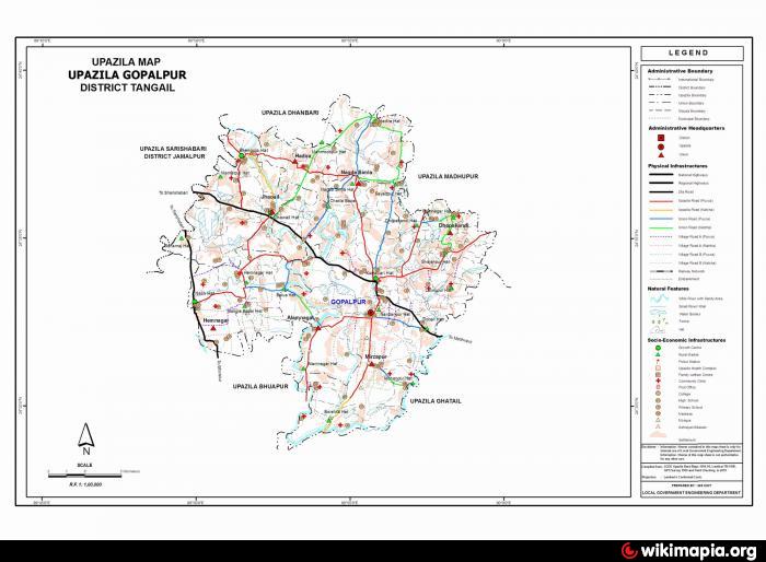
Gopalpur Upazila (Tangail district) with an area of 193.37 sq km, is bounded by Madhupur upazila on the north, Ghatail and Bhuapur upazilas on the south, Ghatail and Madhupur upazilas on the east, Sarishabari and Bhuapur upazilas on the west. Main rivers are Jhinai, Atrai and Bairan; main depressions are Helancha Beel, Barashila Beel and Gaila Beel.
The geographic coordinates of Gopalpur town are 24.5536555N 89.9252015E degree. Gopalpur (Town) consists of 9 wards and 35 mahallas. The Gopalpur municipality was established in 1974. It has an area of 23.12 sq km. The town has a population of 52131; male 50.72%, female 49.28%. The literacy rate among the town people is 40%. It has one dakbungalow.
The Gopalpur thana, now an upazila, was established in 1920. The upazila consists of one municipality, 10 union parishads, 162 mouzas and 146 villages.
Archaeological relics and monuments Khamarbari Mosque.
As of 1991 Bangladesh census, Population 252747; male 50.98, female 49.2%; Muslim 95.5%, Hindu 4.4% and others 0.1%.
Literacy and educational institutions Average literacy 28.4%; male 33.8%, female 22.7%. Most noted are Gopalpur College, Suti V.M. High School, Jhoail Rani Hemantakumari High School.
Main occupations Agriculture 53.35%, agricultural labourer 20.59%, wage labourer 2.15%, industry 9.31%, hawker 1.87%, service 3.98%, others 8.75%.
Land use Total land under cultivation 15510 hectares; single crop11%, double crop 49% and treble crop land 40%.
Land control Among the peasants 40% are landless, 30% small, 20% intermediate and 10% rich.
Fisheries, dairies, poultries Fishery 54, diary 30 and poultry 12.
Manufactories Gopalpur Textile Mill.
Cottage industries Goldsmith 50, blacksmith 75, potteries 250, bamboo work 250, carpenter 300 and welding 25.
NGO activities Operationally important NGOs are brac, asa, SDS and SIDO.
Health centres Upazila health complex 1, satellite clinic 2, family planning centre 7.
Nearby cities:
Coordinates: 24°33'17"N 89°55'40"E
- Sarishabari Upazila 37 km
- Shaghatta Upazila 89 km
- Gobindaganj Upazila 105 km
- Abhaynagar Upazila HQ 176 km
- Bholahat Upazila HQ 181 km
- Fakirhat Upazila HQ 197 km
- Kachua Upazila HQ 210 km
- Koyra Upzila HQ 251 km
- Maidi Vdc 639 km
- Samote Union Council 1879 km
- Charsimla By bulbul 01712570736 5.9 km
- kabariabari villege 13 km
- pingna 14 km
- Dhanbari Palace (Nawab-bari) 14 km
- Jamuna Fertilizer Company Limited (JFCL) 17 km
- JFCL Colony 17 km
- Murad hassan 21 km
- Madhupur Tract 21 km
- Dhaka Division 62 km
- Rajshahi Division 123 km