Salome, Arizona
USA /
Arizona /
Salome /
World
/ USA
/ Arizona
/ Salome
World / United States / Arizona
CDP - Census Designated Place
Add category


Salome AZ, 85348 "Where She Danced"
Town site established by Charles Pratt and Dick Wick Hall and his brother Earnest in 1905. Dick Wick Hall was famous for his pet frog (a logo for the town today). Mrs. Salome Pratt is the one that danced in the desert and gave the town it's name and logo "Where she danced"
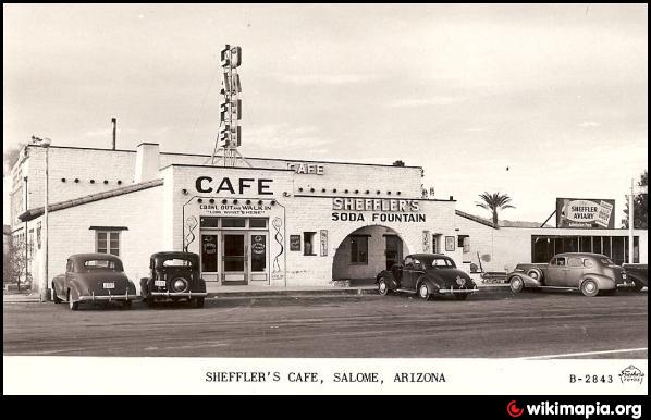
Wiley's Texaco Service Station is now the Cactus Bar & Restaurant.
For more info: www.in-the-desert.com/salome.html
---MORE--- Posted By Sammy-D (Don't forget to check out the photos of this area!)
Local Government Web site >>> www.azoutback.com/salome.htm
Prepared by the ARIZONA DEPARTMENT OF COMMERCE (This post is not for commercial purposes)
Salome and Wenden are the most eastern communties in La paz
County. On State Highway 60, the old Phoenix to Los Angeles
route, they are 55 miles west of Wickenburg, 50 miles east of the
Colorado River, and approximately 103 miles west of Phoenix. In
late 1904, Charles Pratt, with the help of Ernest and Dick Wick
Hall, established Salome. Dick Wick Hall capitalized on the heat
of the desert and created the story of how the town was named.
According to Hall, Mrs. Salome Pratt took off her shoes and
danced when the hot sand burned her feet. Thus, the town
became "Salome, where she danced."
Tourism is the major economic acitivity. Winter visitors provide major
revenue for the communities. The retail trade employs many. Major
business include four construction companies, 11 restaurants, Arizona
Soils Composting and Sonas Soils Resource Recovery of Arizona.
Agriculture plays a secondary economic role. Approximately 12,000-
15,000 acres are used to grow melons, garbanzo beans, alfalfa,
pisachios, wheat and cotton. Cattle ranching is also important to the
area's economy.
Salome/Wenden has many designated wilderness areas including
Harquahala Mountains, Hummingbird Springs, Big Horn Mountains and
Eagletail Mountains. Salome/Wenden is also the gateway to Alamo Lake
State Park. Visitors can enjoy camping, swimming, boating, hiking,
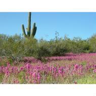
canoeing and bass fishing. For nature lovers, there are wildflowers in the
spring and many species of birds and water fowl.
Utilities
Electricity APS (Statewide) 800.253-9405
Natural Gas Southwest Gas Corp. (statewide) 800.766.9722
Sewer Septic tanks
Telephone TDS Telecom 928.927.6345
Water Keaton Dev. Co./Indian Hills Water 520.859.3241
Water Salome Water Company 520.859.3547
Water Wenden Water Improvement 520.859.3456
Founded: 1904
Incorporated: No
Elevation: 1,890
Located in La Paz County
Distance to Major Cities:
Phoenix: 103 miles
Tucson: 275 miles
Nearby Highways: HWYS US 60, nearby I-10
Town site established by Charles Pratt and Dick Wick Hall and his brother Earnest in 1905. Dick Wick Hall was famous for his pet frog (a logo for the town today). Mrs. Salome Pratt is the one that danced in the desert and gave the town it's name and logo "Where she danced"
Wiley's Texaco Service Station is now the Cactus Bar & Restaurant.
For more info: www.in-the-desert.com/salome.html
---MORE--- Posted By Sammy-D (Don't forget to check out the photos of this area!)
Local Government Web site >>> www.azoutback.com/salome.htm
Prepared by the ARIZONA DEPARTMENT OF COMMERCE (This post is not for commercial purposes)
Salome and Wenden are the most eastern communties in La paz
County. On State Highway 60, the old Phoenix to Los Angeles
route, they are 55 miles west of Wickenburg, 50 miles east of the
Colorado River, and approximately 103 miles west of Phoenix. In
late 1904, Charles Pratt, with the help of Ernest and Dick Wick
Hall, established Salome. Dick Wick Hall capitalized on the heat
of the desert and created the story of how the town was named.
According to Hall, Mrs. Salome Pratt took off her shoes and
danced when the hot sand burned her feet. Thus, the town
became "Salome, where she danced."
Tourism is the major economic acitivity. Winter visitors provide major
revenue for the communities. The retail trade employs many. Major
business include four construction companies, 11 restaurants, Arizona
Soils Composting and Sonas Soils Resource Recovery of Arizona.
Agriculture plays a secondary economic role. Approximately 12,000-
15,000 acres are used to grow melons, garbanzo beans, alfalfa,
pisachios, wheat and cotton. Cattle ranching is also important to the
area's economy.
Salome/Wenden has many designated wilderness areas including
Harquahala Mountains, Hummingbird Springs, Big Horn Mountains and
Eagletail Mountains. Salome/Wenden is also the gateway to Alamo Lake
State Park. Visitors can enjoy camping, swimming, boating, hiking,
canoeing and bass fishing. For nature lovers, there are wildflowers in the
spring and many species of birds and water fowl.
Utilities
Electricity APS (Statewide) 800.253-9405
Natural Gas Southwest Gas Corp. (statewide) 800.766.9722
Sewer Septic tanks
Telephone TDS Telecom 928.927.6345
Water Keaton Dev. Co./Indian Hills Water 520.859.3241
Water Salome Water Company 520.859.3547
Water Wenden Water Improvement 520.859.3456
Founded: 1904
Incorporated: No
Elevation: 1,890
Located in La Paz County
Distance to Major Cities:
Phoenix: 103 miles
Tucson: 275 miles
Nearby Highways: HWYS US 60, nearby I-10
Wikipedia article: http://en.wikipedia.org/wiki/Salome,_Arizona
Nearby cities:
Coordinates: 33°46'41"N 113°36'4"W
- Fortuna Foothills, Arizona 144 km
- Desert Center, California 174 km
- Dolan Springs, Arizona 223 km
- White Hills, Arizona 235 km
- Borrego Springs, California 266 km
- Enterprise, Nevada 299 km
- Paradise, Nevada 300 km
- Pauma Valley, California 321 km
- Pahrump, Nevada 378 km
- Inyokern, California 449 km
- Harquahala Mountain 24 km
- Harquahala Mountains 25 km
- Harcuvar Mountains 27 km
- Crop Circles 27 km
- Harcuvar Mountains Wilderness 30 km
- Little Buckskin Mountains 38 km
- Rancho de Vaqueros 40 km
- Aguila, Arizona 42 km
- Alamo Lake State Park 54 km
- Alamo Lake 55 km