1111 Prince Edward Street (Fredericksburg, Virginia)
USA /
Virginia /
Falmouth /
Fredericksburg, Virginia /
Prince Edward Street, 1111
World
/ USA
/ Virginia
/ Falmouth
World / United States / Virginia
house, place with historical importance
fredericksburg.com/News/FLS/2010/122010/12172010/594662
As with all the lots along nearby streets, the recorded history of this property dates back to Fielding and Betty Washington Lewis, who owned and subdivided much of the land around Kenmore that became the nearby neighborhoods.
According to records and maps researched in 1996 by Margaret D. Lynn for the Historic Fredericksburg Foundation's marker program, there had apparently been a structure at 1111 Prince Edward continuously since 1805.
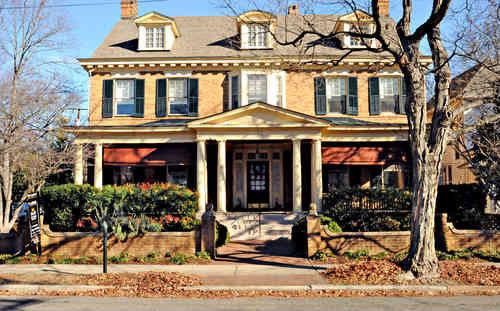
In 1914, G. Frank Timberlake bought the property and had the existing structure moved to another site. That cleared that way for him to commission Philip Stern and Frank Stearns to design and build, respectively, a stately new Colonial that researcher Lynn refers to as Georgian Revival.
Only from 1944 to 1954 was the home owned by someone other than a Timberlake or the Bakers, and that was the William Herbert Owen family.
As with all the lots along nearby streets, the recorded history of this property dates back to Fielding and Betty Washington Lewis, who owned and subdivided much of the land around Kenmore that became the nearby neighborhoods.
According to records and maps researched in 1996 by Margaret D. Lynn for the Historic Fredericksburg Foundation's marker program, there had apparently been a structure at 1111 Prince Edward continuously since 1805.
In 1914, G. Frank Timberlake bought the property and had the existing structure moved to another site. That cleared that way for him to commission Philip Stern and Frank Stearns to design and build, respectively, a stately new Colonial that researcher Lynn refers to as Georgian Revival.
Only from 1944 to 1954 was the home owned by someone other than a Timberlake or the Bakers, and that was the William Herbert Owen family.
Nearby cities:
Coordinates: 38°18'16"N 77°27'49"W
- Rapidan Dam Canal of the Rappahannock Navigation 15 km
- Battle of Chancellorsville 18 km
- Battle of the Wilderness 27 km
- Payne's Farm Battlefield Site 33 km
- Prince William Forest Park 37 km
- Marine Corps Base Quantico 39 km
- Battle of Kelly's Ford 39 km
- Auburn Farm 47 km
- Oakwood Farm 59 km
- Manassas National Battlefield Park 61 km
- Downtown Fredericksburg 0.4 km
- University of Mary Washington 1.1 km
- College Heights 1.3 km
- Bowman Center 3.1 km
- Sylvania Heights 3.6 km
- Argyle Heights 3.6 km
- River Meadows 4.2 km
- Duff McDuff Green Memorial Park 4.5 km
- Stafford County, Virginia 13 km
- Spotsylvania County, Virginia 21 km