Supersonic Naval Ordnance Research Track (SNORT)
| military
USA /
California /
China Lake Acres /
World
/ USA
/ California
/ China Lake Acres
World / United States / California
military
Add category
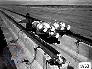

The Supersonic Naval Ordnance Research Track (SNORT). A facility in which rocket-powered sleds scream down a test track at up to Mach 4.
SNORT is a 21,550 foot (4.08 mile)long two rail heavy duty precision track. The track is made up of 50 foot lengths of 171 lb/yd crane rail laid at standard gauge. Beging at 11,475 feet the trough in the center of the track functions as a water brake extending 10,075 feet to the end of the track.
In over 50 years, SNORT has logged more than 9,000 track test runs.
Wikipedia article: http://en.wikipedia.org/wiki/Rocket_sled
Nearby cities:
Coordinates: 35°42'14"N 117°44'27"W
- Naval Air Weapons Station China Lake, South Range 29 km
- Naval Air Weapons Station China Lake, North Range 60 km
- Fort Irwin National Training Center 60 km
- Edwards AFB / Dryden Flight Research Center (EDW/KEDW) 84 km
- Edwards Air Force Base 85 km
- Desert Warfare Training area 92 km
- Palmdale Regional Airport/United States Air Force Plant 42 123 km
- Marine Corps Air Ground Combat Center Twentynine Palms 156 km
- Targets for Red Flag exercises 221 km
- Range 500 222 km
- Inyokern, California 6 km
- Inyokern Airport Kern County Airport (IVK/KIVK) 9 km
- Mirror Lake (dry) 11 km
- Short Canyon 14 km
- Valley View Airport (closed) 16 km
- Plan B Raceway Rally Track 18 km
- Pearsonville, California 18 km
- Coso Volcanic Field 33 km
- Sugarloaf Mountain 37 km
- Naval Air Weapons Station China Lake, South Range 54 km
Comments