Fort Belgica
Indonesia /
Maluku /
Amahai /
World
/ Indonesia
/ Maluku
/ Amahai
World
fortification, historical building, star fort
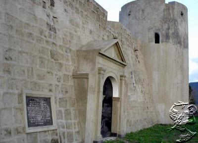
This fort was first built in 1611 under the order of Pieter Both, the first Governor General of the Dutch East Indies and was rebuilt and restored for several times. It was buit to protect Dutch monopolistic nutmeg trade in the island after conquering the local Banda people.
www.youtube.com/watch?v=jvEZgtrzVsI
_________
Ih high definition:
www.youtube.com/watch?v=WUsqEPKWRZ0
Fort Belgica is the fort located at a height of 30 meters above sea level, on top of the hills at southwest of the Naira island, Central Maluku. The fort was built in 1611 during the Governor-General Pieter Both period.
The unique shape of pentagon resemble to the Pentagon building in the Washington DC, United States.
Wikipedia article: http://en.wikipedia.org/wiki/Fort_Belgica
Nearby cities:
Coordinates: 4°31'34"S 129°53'55"E
- Saparua 176 km
- Buton Fortress Palace 816 km
- Mt. Sanu (1064 m) 825 km
- Ancient Plered 2189 km
- Bekas KRATON KERAJAAN MATARAM KUNO ( HINDHU - BUDDHA ) MATARAM SANJAYA - SYAILENDRA WAMCA. 2191 km
- Sultan Palace Fort (Beteng Kraton) 2193 km
- Ir. H. Juanda Forest Park (TAHURA) 2480 km
- Scriven Battery site (WW2) 3420 km
- Royal Hill of Ambohimanga - UNESCO World Heritage Site 9051 km
- Bentiaba, Angola-Provincia de Namibe 12831 km
- Banda Naira Island 1.1 km
- Banda Besar island 2 km
- Banda Api Volcano 2.1 km
- Banda Api Island 2.2 km
- The Banda Islands 7.1 km
- Ai island 14 km
- Hatta Island 17 km
- Run Island 24 km
- Manuk Island 122 km
- Banda Sea 203 km