Ishwarganj Upazila HQ
Bangladesh /
Maimansingh /
Ishwarganj /
World
/ Bangladesh
/ Maimansingh
/ Ishwarganj
World / Bangladesh / Dhaka / Mymensingh / Nasirabad
township, subdistrict, fourth-level administrative division, local government
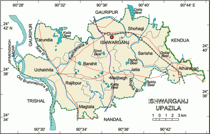
Ishwarganj Upazila (Mymensingh district) with an area of 286.19 sq km, is bounded by Gauripur upazila on the north, Nandail upazila on the south, Kendua upazila on the east, trishal on the west. Main rivers are old Brahmaputra, Mogha, Soai and Kanchamatia; noted depressions are Kaila, Dalia, Sinni, Diga and Katla beels.
The geographic coordinates of Ishwarganj town are Ishwarganj (Town) a municipal town, consists of 9 wards and 10 mahallas. The area of the town is 13.02 sq km. It has a population of 25108; male 51.75%, female 48.25%. The density of population is 1928 per sq km. Literacy rate among the town people is 41.2%; male 29.09%, female 16.04%.
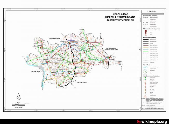
Administration: Ishwarganj thana, now an upazila, was established in 1936. The upazila consists of one municipality, 11 union parishads, 293 mouzas, 296 villages.
Religious institutions Mosque 343, temple 18. Most noted mosques are Bushsoma mosque (1600), Notuapara mosque (1625).
As of 1991 Bangladesh census, population 306977: male 50.80%, female 49.20%. Muslim 95.08%, Hindu 4.15%, Buddhist 0.19%, Christian 0.19% and others 0.48%.
Literacy and educational institutions: Average literacy 22.2%; male 27.9%, female 16.4%. Educational institutions: college 6, high school 21, government primary school 92, non-government primary school 14. Noted educational institutions: Atharabari Mahim Chandra High School (1910), Charanikala High School (1913), Baleshwai High School (1916), Charanikala Primary School (1913), Bishwari Primary School (1916).
Main occupations: Agriculture 57.66%, forestry and fishing 1.49%, agricultural labourer 19.3%, wage labourer 2.56%, commerce 6.56%, service 2.81%, others 9.62%
Land use: Cultivable land 27981.79 hectares; single crop 8.28%, double crop 81.53% and treble crop land 10.19%.
Land control: Among the peasants 13.52% are landless, 25.51% marginal, 43.88% small, 14.72% intermediate and 2.37% rich.
Fisheries, dairies, poultries Fishery 1, dairy 19, poultry 43 and hatchery and nursery 60.
Communication facilities Roads: pucca 24 km, semi pucca 10 km and mud road 555 km.
Manufactories Flour mill 63, Boiler 9.
Cottage industries: Weaving 64, goldsmith 48, blacksmith 62, potteries 60, wood work 225, tailoring 232, bamboo work 151 and welding 53.
NGO activities Operationally important NGOs are brac, asa, caritas, grameen bank and SDS Foundation.
Health centres: Upazila health complex 1, satellite clinic 9 and family planning centre 6.
The geographic coordinates of Ishwarganj town are Ishwarganj (Town) a municipal town, consists of 9 wards and 10 mahallas. The area of the town is 13.02 sq km. It has a population of 25108; male 51.75%, female 48.25%. The density of population is 1928 per sq km. Literacy rate among the town people is 41.2%; male 29.09%, female 16.04%.
Administration: Ishwarganj thana, now an upazila, was established in 1936. The upazila consists of one municipality, 11 union parishads, 293 mouzas, 296 villages.
Religious institutions Mosque 343, temple 18. Most noted mosques are Bushsoma mosque (1600), Notuapara mosque (1625).
As of 1991 Bangladesh census, population 306977: male 50.80%, female 49.20%. Muslim 95.08%, Hindu 4.15%, Buddhist 0.19%, Christian 0.19% and others 0.48%.
Literacy and educational institutions: Average literacy 22.2%; male 27.9%, female 16.4%. Educational institutions: college 6, high school 21, government primary school 92, non-government primary school 14. Noted educational institutions: Atharabari Mahim Chandra High School (1910), Charanikala High School (1913), Baleshwai High School (1916), Charanikala Primary School (1913), Bishwari Primary School (1916).
Main occupations: Agriculture 57.66%, forestry and fishing 1.49%, agricultural labourer 19.3%, wage labourer 2.56%, commerce 6.56%, service 2.81%, others 9.62%
Land use: Cultivable land 27981.79 hectares; single crop 8.28%, double crop 81.53% and treble crop land 10.19%.
Land control: Among the peasants 13.52% are landless, 25.51% marginal, 43.88% small, 14.72% intermediate and 2.37% rich.
Fisheries, dairies, poultries Fishery 1, dairy 19, poultry 43 and hatchery and nursery 60.
Communication facilities Roads: pucca 24 km, semi pucca 10 km and mud road 555 km.
Manufactories Flour mill 63, Boiler 9.
Cottage industries: Weaving 64, goldsmith 48, blacksmith 62, potteries 60, wood work 225, tailoring 232, bamboo work 151 and welding 53.
NGO activities Operationally important NGOs are brac, asa, caritas, grameen bank and SDS Foundation.
Health centres: Upazila health complex 1, satellite clinic 9 and family planning centre 6.
Nearby cities:
Coordinates: 24°41'16"N 90°36'3"E
- Gafargaon Upazila 22 km
- Kapashia Upazila 48 km
- Dhobaura Upazila 62 km
- Rupganj Upazila 82 km
- Keraniganj Upazila 110 km
- Matlab Upazila (North) Area 132 km
- Lohajang Upazila 133 km
- Patiya Upazila (পটিয়া) 287 km
- Chandanaish Upazila 301 km
- Banshkhali Upazila (বাঁশখালী উপজেলা) 307 km
- Fatema Nogor 15 km
- Bangladesh Agricultural University (BAU) 18 km
- South Balipara 20 km
- chormadakhali 20 km
- Kazir Simla, Trishal 21 km
- kadam rasulpur 22 km
- Atpara Upazila 22 km
- Momenshahi Cantonment 23 km
- Netrakona Sadar Upazila 27 km
- Dhaka Division 66 km
Comments