Ship Altair (Rio Grande)
Brazil /
Rio Grande do Sul /
Rio Grande
World
/ Brazil
/ Rio Grande do Sul
/ Rio Grande
World / Brazil / Rio Grande do Sul / Rio Grande
shipwreck
Add category

Wreck in 1977.
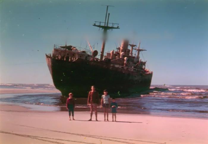
The flotilhense João Reguffe Rio Grande found this photo of the ship Altair, stranded on the beach in Rio Grande Casino, which, he says, is apparently rare. Doubt is the place which would be passing by. Hypotheses that places: San Sebastian, Saints? ... Or could he asks, is the passage in the lighthouse Itapuã?
Photo and text:
flotilha.blogspot.com.br/search/label/Navio 22Altair% 20% 22%
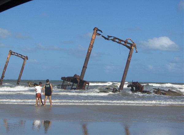
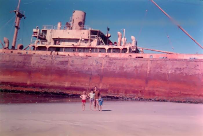
The solemn ship Altair lies at Cassino Beach since June 1976 when it ran aground on the sandy shore. The cargo ship failed to withstand the gales that winter and ended up buried on the coast, becoming one of the three major tourist attractions of the beach. Today the ship is literally disappearing with the passage of time, sea air and sinking in the sand, but is still a point of visiting and a backdrop for photos, though so deteriorated.
source:
blogdoriograndino.wordpress.com/dicas-de-saude-com-o-do...
The flotilhense João Reguffe Rio Grande found this photo of the ship Altair, stranded on the beach in Rio Grande Casino, which, he says, is apparently rare. Doubt is the place which would be passing by. Hypotheses that places: San Sebastian, Saints? ... Or could he asks, is the passage in the lighthouse Itapuã?
Photo and text:
flotilha.blogspot.com.br/search/label/Navio 22Altair% 20% 22%
The solemn ship Altair lies at Cassino Beach since June 1976 when it ran aground on the sandy shore. The cargo ship failed to withstand the gales that winter and ended up buried on the coast, becoming one of the three major tourist attractions of the beach. Today the ship is literally disappearing with the passage of time, sea air and sinking in the sand, but is still a point of visiting and a backdrop for photos, though so deteriorated.
source:
blogdoriograndino.wordpress.com/dicas-de-saude-com-o-do...
Nearby cities:
Coordinates: 32°17'31"S 52°15'35"W
- App. position of S/V CONCORDIA sinking 17.02.2010. 1221 km
- ARA San Juan submarine (Approximate) 1708 km
- Approximate sinking location: HMS Monmouth 2040 km
- Wreck of USS La Moure County (LST-1194) 2066 km
- Wreck of SMS Scharnhorst 2271 km
- Wreck of SMS Gneisenau 2291 km
- Wreck of ARA General Belgrano 2672 km
- Wreck of USS St. Louis (CL-49) / NAe Tamandare (C-12) 4602 km
- approximate Sinking position of auxiliary cruiser Atlantis 4760 km
- Spacecraft cemetery 7777 km
Comments