Baker Island Daymark
Kiribati /
Phoenix Islands /
Pyramid Point /
World
/ Kiribati
/ Phoenix Islands
/ Pyramid Point
World / United States Minor Outlying Islands
lighthouse, daymark / daybeacon, navigation beacon - marine
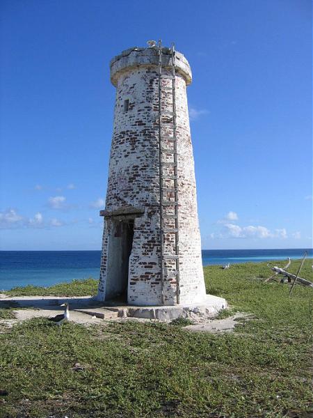

Built in 1935 as part of a short-lived US colonization attempt, cut short by the Second World War.
Wikipedia article: http://en.wikipedia.org/wiki/Baker_Island
Nearby cities:
Coordinates: 0°11'44"N 176°29'3"W
- Hen and Chicken Shoals light 10608 km
- MOA Cayo Moa Grande light 11215 km
- PUERTO CABELLO Fortin Solano 12034 km
- PUERTO CABELLO Warship Quay SE 12036 km
- ISLA PICUDA CHICA Light 12413 km
- Metal Man Day Markers 14126 km
- Brownstown Day Markers 14128 km
- Crookhaven Light 14153 km
- Gwennap Head Daymarks (Black & Red) 14377 km
- Grand Amfroque beacons 14475 km
- Baker Island 0.6 km
- Baker Island Airstrip (BAR) 0.7 km
- Radio Towers 1.3 km
- Howland Island Small Boat Landing 69 km
- Itascatown Ruins 70 km
- Guano Company Ruins 70 km
- Howland Island 70 km
- Kamakaiwi Field (site) 70 km
- UD-4 Aft Section 349 km
- UD-4 Forward Section 349 km