BT-11 Piney Island (R-5306A)
USA /
North Carolina /
Oriental /
World
/ USA
/ North Carolina
/ Oriental
World / United States / North Carolina
military, United States Marine Corps, proving ground
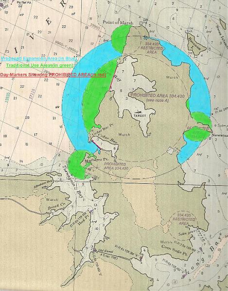
BT-11 is a multi-purpose target complex encompassing all of Piney Island designed to provide training in the delivery of conventional and special weapons. As part of the Mid-Atlantic Electronic Warfare Range (MAEWR), Piney Island is used by various military groups including active-duty personnel and reservists to train with air-to-ground deliveries with inert ordnance, laser systems operations and radar exercises. Small boat naval excercises are also conducted on and around the facility.
www.globalsecurity.org/military/facility/piney-island.h...
www.cherrypoint.marines.mil/News/Article/607733/piney-i...
www.globalsecurity.org/military/facility/piney-island.h...
www.cherrypoint.marines.mil/News/Article/607733/piney-i...
Nearby cities:
Coordinates: 35°1'11"N 76°27'35"W
- Marine Corps Air Station (MCAS) Cherry Point 44 km
- Onslow Beach 91 km
- Long Shoal Naval Ordnance Area 94 km
- Dare Bombing Range 97 km
- Impact Zone 98 km
- Camp Lejeune 109 km
- Harvey Point - CIA Training Facility 122 km
- Academi Training Facility/USTC 165 km
- Naval Support Activity Northwest Annex 174 km
- Military Ocean Terminal Sunny Point 180 km
- Cedar Island National Wildlife Refuge 12 km
- Carteret County, North Carolina 18 km
- Pamlico County, North Carolina 22 km
- Cape Lookout National Seashore 24 km
- Hyde County, North Carolina 47 km
- Gull Rock Game Land 50 km
- Craven County, North Carolina 55 km
- Lake Mattamuskeet 60 km
- Beaufort County, North Carolina 61 km
- Cape Hatteras National Seashore 81 km