Mapandan
| town, municipality, third-level administrative division
Philippines /
Ilocos /
Mapandan /
World
/ Philippines
/ Ilocos
/ Mapandan
World / Philippines / Pangasinan / Mapandan
town, municipality, third-level administrative division
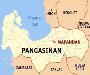
Municipality of Mapandan, Province of Pangasinan
Land Area: 19.40 km²
ZIP Code: 2429
Mapandan is a landlocked municipality in the province of Pangasinan in the Philippines. As of the 2010 Census, it had a population of 34,439 people.
The municipality of Mapandan was formerly a barrio of Mangaldan. In the year 1909, under the initiative of Rev. Father Benigno Jimenez, a Parish Priest of Mangaldan, the barrio was made into a separate municipality. The name "mapandan" was derived from the word "pandan", a native palm whose leaves will add aroma to the cooked rice if cooked with it.
Mapandan is politically subdivided into 15 barangays:
-Amanoaoac
-Apaya
-Aserda
-Baloling
-Coral
-Golden
-Jimenez
-Lambayan
-Luyan (Luyan South)
-Nilombot
-Pias
-Poblacion
-Primicias
-Santa Maria
-Torres
Pangasinan Webpage: www.pangasinan.org/mapandan/
Blogspot: gopangasinan.blogspot.com/2007/01/mapandan-pangasinan.h...
Wikipedia article: http://en.wikipedia.org/wiki/Mapandan,_Pangasinan
Nearby cities:
Coordinates: 16°0'49"N 120°27'21"E
- Mangatarem 35 km
- San Jose 61 km
- Santa Cruz 65 km
- Mabini 66 km
- Candelaria 68 km
- Bokod 69 km
- Capas 69 km
- Kayapa 74 km
- Botolan 89 km
- Subic 117 km
- San Ramon 2.8 km
- Mermer 3 km
- zone 5-7 3.6 km
- Sitio Madriaga 3.7 km
- Manaoag Town Proper 4.7 km
- Babasit 5.1 km
- Calaocan 5.3 km
- Tebuel 5.3 km
- Sapang 6 km
- Pangasinan 13 km
Comments