Morrelganj upazila
Bangladesh /
Bagar Hat /
Morrelganj /
World
/ Bangladesh
/ Bagar Hat
/ Morrelganj
World / Bangladesh / Khulna / Khulna / Bagerhat
township, subdistrict, fourth-level administrative division, local government
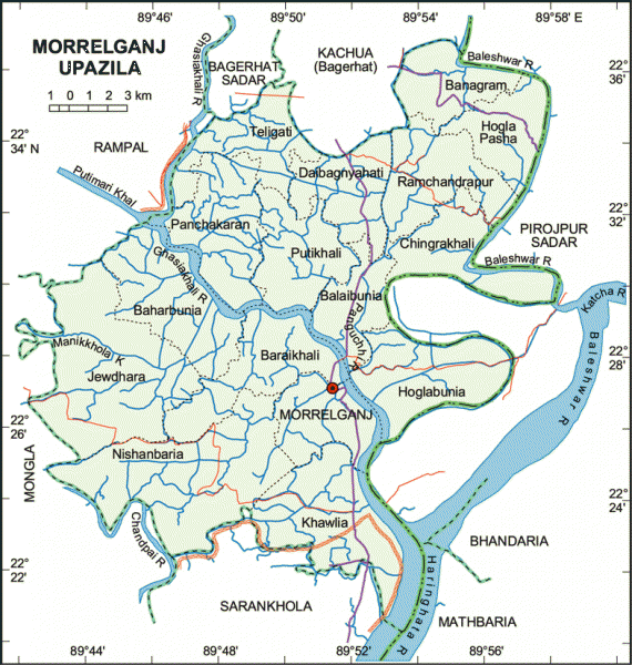
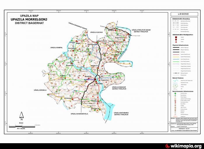
Morrelganj Upazila (Bagerhat district) with an area of 460.91 sq km, is bounded by Bagerhat sadar and Kachua upazilas on the north, Sarankhola and Mathbaria upazilas on the south, Pirojpur sadar and Bhandaria upazilas on the east, Rampal and Mongla upazilas on the west. Main rivers: Baleshwar, Ghasiakhali, Panguchi and Bhola.
The location of the Morrelganj town is 22.4552485N 89.8554799E. Morrelganj (Town) consists of 9 wards and 12 mahallas. The area of the town is 15.36 sq km. The town has a population of 22136; male 51.76%, female 48.24%. The density of population is 1441per sq km. The town has one dakbungalow.
Morrelganj thana was established in 1909 and was turned into an upazila in 1985. It consists of 1 municipality, 16 union parishads, 121 mouzas and 184 villages.
Archaeological heritage Neelkuthi (1849) and Rajbari at Bonogram.
Historical events: During the British rule Henry Morrel established Kuthi Bari. Morrelganj is named after him. He conducted torture in the area. In protest, peasant rebellion spread under the leadership of Rahimullah of Baraikhali in 1861.
Religious institutions: Mosque 618, temple 65.
As of the 1991 Bangladesh census: Population 321153; male 50.48% and female 49.52%; Muslim 86.59%, Hindu 13.28% and other 0.13%.
Literacy and educational institutions: Average literacy 49.5%; male 53.9% and female 40%. Educational institutions: college 6, high school 76, madrasa 291, most noted of which is AC Laha Pilot High School (1924).
Cultural organisations: Press club 1, theatre group 2, public library 1, opera party 1 and rural organisation 7.
Main occupations: Agriculture 35.49%, fishing 3.65%, agricultural labourer 20.73%, wage labourer 6.85%, commerce 11.85%, transport 1.4%, service 5.6%, others 14.43%.
Land use: Cultivable land 31778.22 hectares; single crop 73.14%, double crop 15.30% and treble crop 11.56%.
Fisheries, dairies and poultries Fishery 960, poultry 13, dairy 8, hatchery 1.
Communication facilities- Roads: pucca 59 km, semi pucca 82 km and mud road 765 km.
Manufactories: Ice factory 4, rice mill 59, saw mill 46 and welding 30.
Cottage industries: Bamboo and cane work 144 and embroidery work 10.
NGO activities: brac, proshika, asa, grameen bank, Bima Prokalpo, Ranar Uddipan, Mashuk, Gono Shastho Kendra, Dak Deya Jai, CDC.
Health centres: Upazila health complex 1, satellite clinic 1, health and family planning centre 16, veterinary hospital 1 and private clinic 1
Nearby cities:
Coordinates: 22°27'8"N 89°51'3"E
- Kachua Upazila HQ 25 km
- Fakirhat Upazila HQ 43 km
- Koyra Upzila HQ 61 km
- Abhaynagar Upazila HQ 84 km
- Sarishabari Upazila 265 km
- Shaghatta Upazila 313 km
- Gobindaganj Upazila 317 km
- Bholahat Upazila HQ 326 km
- Maidi Vdc 797 km
- Samote Union Council 2018 km
- Bhorbunia Union, Morrelganj Upazila 8.8 km
- Zianagar Upazila 10 km
- Nishanbaria Union, Morrelganj Upazila 13 km
- sangdia 16 km
- Pirojpur District Town 19 km
- Sadar upazila to sundarban union road, Bagerhat 20 km
- Sundarban Unon, Mongla Upazila 22 km
- Barishal Division 52 km
- Khulna Division 73 km
- Sundarbans 86 km