Brahmanpara Upazila HQ
Bangladesh /
Komilla /
World
/ Bangladesh
/ Komilla
/ Komilla
World / Bangladesh / Chittagong / Comilla / Comilla
township, subdistrict, fourth-level administrative division, local government
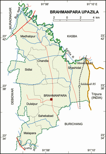
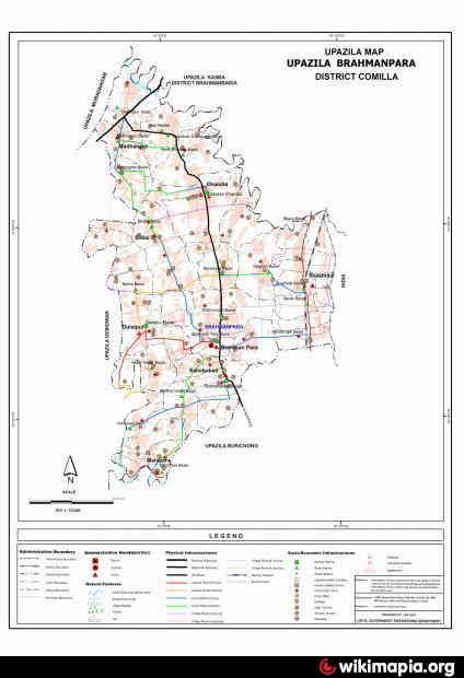
Brahmanpara Upazila (Comilla district) with an area of 128.90 sq km, is bounded by kasba and Muradnagar upazilas on the north, Burichang upazila on the south, Indian state of tripura, Kasba upazila on the east and Bebidwar, Muradnagar upazilas on the west. Main rivers are Gumti, Salda and Ghungur; Makimpur Go-bak Beel, Shaitshalar Dam, Pellar Beel, Baroni Beel at Jamtali are noted depressions.
The location of the Brahmanpara town is 23.6145766N 91.1025923E. Brahmanpara (Town) consists of two mouzas. The area of the town is 1.97 sq km. The town has a population of 3059; male 53.42%, female 46.58%; population density is 1553 per sq km. Literacy rate among the town people is 41%; male 43.40%, female 36.3%.
Once Brahmanpara was included in Kasba thana and it was included in Burichang thana in 1954. In 1968, Brahmanpara police out post was established and in 1976 it was separated from Burichang thana and became an independent thana. It was turned into an upazila in 1983. The upazila consists of 8 union parishads, 53 mouzas and 65 villages.
Archaeological heritage and relics: Tombs of Panch Pir (1815) west side of the Shashidal Rail Station, Shaitshala Jami Mosque (1719).
As of the 1991 Bangladesh census: Population 161906; male 51%, female 49%; Muslim 96.14%, Hindu 3.36%, Christian 0.12%, Buddhist 0.10% and others 0.28%; ethnic nationals 8 families.
Religious institutions: Mosque 155, temple 12, tomb 4 and sacred place 5. Noted religious institutions: Baghai Shah Jami Mosque, Shaitshala Jami Mosque, tombs of Panch Pir at Shashidal.
Literacy and educational institutions: Average literacy 32.6%; male 40.25%, female 24.9%. Educational institutions: college 4, high school 26, madrasa 18, government primary school 53, non-government primary school 38, low cost school 9, satellite school 13 and maktab 178. Noted educational institutions: Shashidal Union High School (1890), Chandana K B High School (1920), Brahmanpara Bhagaban High School (1940), Madhabpur Sheikhlal High School (1911) and Sahebabad Degree College (1970).
Cultural organisations: Voluntary organisation 44, club 44, public library 1, cinema hall 1, cooperative society 195, rural community centre 8.
Main occupations: Agriculture 53.74%, agricultural labourer 17.23%, wage labourer 1.94% commerce 9.84%, service 9.67%, and others 7.58%.
Land use: Total cultivable land 8970 hectares, fallow land 19.40 hectares, permanently uncultivable land 32 hectares; single crop 12.04%, double crop 44.89% and treble crop 43.07%; cultivable land under irrigation 92.74%.
Land control: Among the peasants 4.49% are landless, 7.8% marginal, 77.9% small, 9.46% intermediate and 0.35% rich.
Fisheries, dairies, poultries Fishery 3, poultry 15 and hatchery 3 (fish).
Communication facilities- Roads: pucca 25 km, semi pucca 2 km, mud road 278 km; railways 7 km, railway station 2; waterways 27 nautical mile.
Manufactories: Rice mill 44, oil mill 10, flour mill 45, ice factory 9 and saw mill 20.
Cottage industries: Weaving 11, bamboo and cane work 61, blacksmith 95, potteries 110, wood work 71, goldsmith 20, jute and cotton work 23, oil grinding 6, bakery 25, tailoring 72 and others 112.
NGO activities: Operationally important NGOs are brac, asa, grameen bank, proshika and Pages.
Health centres: Upazila health complex 1, sub health centre 3, union clinic 5, satellite clinic 64.
Nearby cities:
Coordinates: 23°36'46"N 91°6'6"E
- Matlab Upazila (North) Area 56 km
- Rupganj Upazila 68 km
- Keraniganj Upazila 88 km
- Lohajang Upazila 90 km
- Kapashia Upazila 96 km
- Gafargaon Upazila 123 km
- Patiya Upazila (পটিয়া) 157 km
- Chandanaish Upazila 172 km
- Banshkhali Upazila (বাঁশখালী উপজেলা) 177 km
- Dhobaura Upazila 192 km
- teta bhomi 5.4 km
- Manora, Brahmonpara, comilla. 6.3 km
- (Manigarchore Bazar) 6.4 km
- Chawra, kosba 7.2 km
- Kangshonagar 7.3 km
- est gram 11 km
- chari para 12 km
- Konaban, India 13 km
- New area of Bishalgarh Sub-Division 19 km
- Tripura 75 km