Fort Ticonderoga
USA /
New York /
Port Henry /
Fort Ti Road, 100
World
/ USA
/ New York
/ Port Henry
World / United States / New York
military, battlefield, fortification, interesting place, historic landmark

100 Fort Ti Road
Ticonderoga, NY 12883
(518) 585-2821
www.fort-ticonderoga.org/
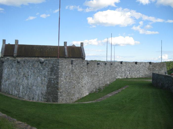
Historic fort which gained fame in the American Revolution. Sometimes referred as Gibraltar of the North for its reputation as an impenetrable fortress. It's location controls vital trade routes and overlooks a stratigic narrow in Lake Champplain.
Originally constructed as Fort Carillon by the French in 1755. In August, 1757 the French used Carillon as a staging ground for their attack against the British on Lake George at Fort William Henry.
In response, in July, 1758 the British under General James Abercrombie assaulted Fort Carillon and were repulsed by the French. This was the only time it was successfully defended in an attack.
A year later the British returned and took the fort and renamed it Ticonderoga. It remained in British control until May, 1775 when a small force lead by Ethan Allen surprised the garrison of 22 British soldiers and seized the fort and its critical supply of gunpowder and artillery.
Many of the cannons inside where moved that winter over-land to Boston where they were placed on Dorchester Heights and used to force the Britsh to abandon Boston.
In 1777 Britsh General John Burgoyne was determined to drive South from Canada along the Hudson river and cut New England off from the rest of the colonies. In early July he ordered cannon placed on nearby Mt Defiance which rendered Ticonderoga defenseless and the American forces abandoned the fort on July 5th.
Following Burgoyne's defeat at Saratoga in October, the fort fell into disuse and was stripped of building materials. Restored in 1909 and declared a National Historic Landmark in 1960, the fort is now in private hands.
Ticonderoga, NY 12883
(518) 585-2821
www.fort-ticonderoga.org/
Historic fort which gained fame in the American Revolution. Sometimes referred as Gibraltar of the North for its reputation as an impenetrable fortress. It's location controls vital trade routes and overlooks a stratigic narrow in Lake Champplain.
Originally constructed as Fort Carillon by the French in 1755. In August, 1757 the French used Carillon as a staging ground for their attack against the British on Lake George at Fort William Henry.
In response, in July, 1758 the British under General James Abercrombie assaulted Fort Carillon and were repulsed by the French. This was the only time it was successfully defended in an attack.
A year later the British returned and took the fort and renamed it Ticonderoga. It remained in British control until May, 1775 when a small force lead by Ethan Allen surprised the garrison of 22 British soldiers and seized the fort and its critical supply of gunpowder and artillery.
Many of the cannons inside where moved that winter over-land to Boston where they were placed on Dorchester Heights and used to force the Britsh to abandon Boston.
In 1777 Britsh General John Burgoyne was determined to drive South from Canada along the Hudson river and cut New England off from the rest of the colonies. In early July he ordered cannon placed on nearby Mt Defiance which rendered Ticonderoga defenseless and the American forces abandoned the fort on July 5th.
Following Burgoyne's defeat at Saratoga in October, the fort fell into disuse and was stripped of building materials. Restored in 1909 and declared a National Historic Landmark in 1960, the fort is now in private hands.
Wikipedia article: http://en.wikipedia.org/wiki/Fort_Ticonderoga
Nearby cities:
Coordinates: 43°50'30"N 73°23'16"W
- Curtis S. Read Scout Reservation 24 km
- Tahawus or Tahawus mine and tailings - Environmental Wasteland 60 km
- Shelburne Farms 64 km
- Weller Pond 88 km
- Former Atlas F LLC site 97 km
- Mount Arab 105 km
- Very long Esker 112 km
- Old Railroad beds 173 km
- old Gallop Canal 1847-1897 192 km
- Submerged alignment of Old Highway 2 194 km
- Mount Independence State Historic Site 1.7 km
- Ticonderoga Elementary/Middle School 4.2 km
- Ticonderoga Municipal Airport (4B6) 4.3 km
- International Paper Company 5.4 km
- Orwell, Vermont 8.2 km
- International Paper Wastewater Treatment 8.8 km
- Buck Mountain 9 km
- Ticonderoga, New York 9 km
- Crown Point, New York 17 km
- Lake Champlain 52 km
Comments