Laksam Upazila HQ
Bangladesh /
Komilla /
Laksham /
World
/ Bangladesh
/ Komilla
/ Laksham
World / Bangladesh / Chittagong / Comilla / Comilla
township, subdistrict, fourth-level administrative division, local government
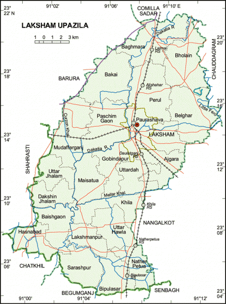
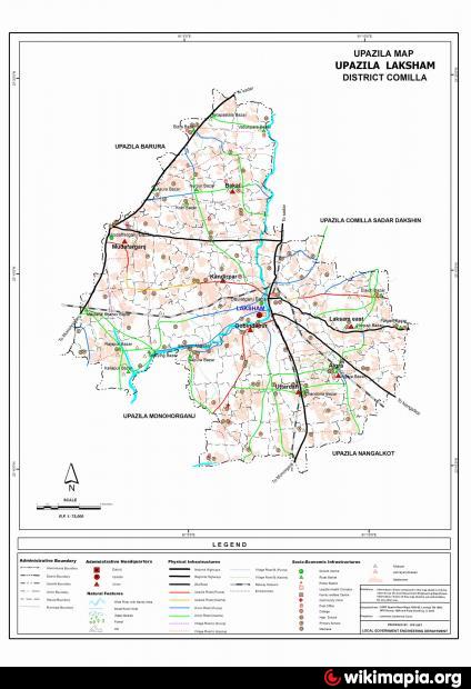
Laksham Upazila (Comilla district) with an area of 429.34 sq km, is bounded by Comilla Sadar and Barura upazilas on the north, Chatkhil, Begumganj and Senbagh upazilas on the south, Nangalkot and Chauddagram upazilas on the east, Barura and Shahrasti upazilas on the west. Main rivers are Dakatia and Little Feni.
The location of Laksam town is 23.2393748N 91.1222308E. Laksham (Town) consists of 9 wards and 31 mahallas. The area of the town is 14.3 sq km. It has a population of 60926; male 52.31%, female 47.69%; density of population is 4261 per sq km. Literacy rate among the town people is 38.3%. Laksham is well known as a commercial town. Laksham Railway Junction is one of the five biggest junctions of Bangladesh.
Laksham thana was turned into an upazila in 1982. The upazila consists of one municipality, 9 wards, 2 police outposts, 25 union parishads, 479 mouzas and 504 villages.
As of the 1991 Bangladesh census: population 513119; male 49.42%, female 50.58%; Muslim 94.32%, Hindu 4.84%, Buddhist 0.70%, Christian 0.05% and others 0.09%.
Religious institutions: Mosque 960, temple 18, Buddhist Vihara 2, tomb 7, most noted are tomb of Gazi Shaheb, Darbar Sharif at Panua, tomb of Pir Shaheb at Kaliapur, tomb of Syed Shah Waliullah Rajapuri Pir Saheb at Rajapur and Buddhist Vihara at Baraigaon.
Literacy and educational institutions: Average literacy 34.4%; male 40.7% and female 28.4%. Educational institutions: college 2, high school 64, junior high school 5, madrasa 59, government primary school 432, non-government primary school 69, satellite school 11, BRAC school 145. Noted educational institutions: Nawab Faizunnesa Government College, Laksham Pilot High School, Harishchar Union High School, Daulatganj Government Primary School, Gazimura Alia Madrasa.
Cultural organisations: Club 2, public library 2, museum 1, cinema hall 2, theatre stage 1 and theatre group 1.
Locally published newspapers and periodicals: Laksham Barta, Joykantha and Weekly Laksham.
Main occupations: Agriculture 34.05%, agricultural labourer 19.08%, wage labourer 3.77%, commerce 11.21%, service 13.55%, transport 3.28%, construction 1.21% and others 13.85%.
Land use: Cultivable land 32707.41 hectares; fallow land 9583.97 hectares; khas land 1959.94 hectares; land under irrigation 15068.39 hectares. Cultivable land per head 0.11 hectare.
Value of land: The market value of the land of the first grade is Tk 10000 per 0.01 hectare.
Main crops: Paddy, wheat, potato, brinjal, tomato, mustard seed and vegetables.
Fisheries, dairies, poultries Poultry 28, fishery 402, hatchery 6, artificial breeding centre 4.
Communication facilities- Roads: pucca 165 km, semi pucca 30 km and mud road 1785 km; waterways 35 nautical mile; railways 57 km; railway junction 1 and railway station 6.
Manufactories: Cigarette factory 2, bidi factory 4, rice mill 3, oil mill 27.
Cottage industries: Total number of cottage industries 280.
NGO activities: Operationally important NGOs are brac, asa, bard, Swanirvar Bangladesh, UNDP, proshika and Muslim Welfare Organisation.
Health centres: Upazila health complex 1, satellite clinic 8 and family planning centre 14.
Website of Laksam Upazila: www.laksam.com/
Ref: www.banglapedia.org/httpdocs/HT/L_0016.HTM
Wikipedia article: http://en.wikipedia.org/wiki/Laksam_Upazila
Nearby cities:
Coordinates: 23°14'13"N 91°7'29"E
- Matlab Upazila (North) Area 64 km
- Lohajang Upazila 98 km
- Rupganj Upazila 99 km
- Keraniganj Upazila 106 km
- Patiya Upazila (পটিয়া) 120 km
- Kapashia Upazila 132 km
- Chandanaish Upazila 136 km
- Banshkhali Upazila (বাঁশখালী উপজেলা) 139 km
- Gafargaon Upazila 161 km
- Dhobaura Upazila 232 km
- Laksam Upazila Health Complex 0.9 km
- Bhogai 2 km
- village: iruain (mithu) 3.7 km
- খিলা বাজার। 7.4 km
- বেলঘর 8.6 km
- Chirpulia bazar 10 km
- Monohorganj Bazar 11 km
- Olipur Bazar 12 km
- Laksmanpur Bazar 15 km
- Feni 37 km