Amigos del Cielo Airpark
USA /
New Mexico /
Lordsburg /
World
/ USA
/ New Mexico
/ Lordsburg
World / United States / New Mexico
airport, runway, airpark
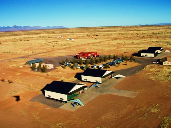
Amigos del Cielo is a homeowner airpark community composed of aviators and astronomers. It has a 5000' main runway with 2000' of access taxiway and a 2500' crosswind runway. Its commercial centerpiece has 4 - 50 x 50 hangers, RV parking, bath house, cafe, movie theater, and greenhouse.
Reference:
www.airnav.com/airport/NM90
www.airparks.com/nm70/Portal/Portal.html
Reference:
www.airnav.com/airport/NM90
www.airparks.com/nm70/Portal/Portal.html
Nearby cities:
Coordinates: 31°54'9"N 109°1'37"W
- Midland Airpark (MDD/KMDD) 653 km
- The Oklahoma Spaceport - Clinton-Sherman Industrial Airpark (CSM/KCSM) 987 km
- Shively Field (SAA/KSAA) 1080 km
- Riverton Municipal Airport (RIW/KRIW) 1244 km
- Worland Municipal Airport (WRL/KWRL) 1348 km
- Sheridan County Airport (SHR/KSHR) 1445 km
- Jumbolair 2587 km
- Spruce Creek Fly In Community 2694 km
- 3C8 Calverton Executive Airpark 3368 km
- Lapangan Terbang Budiarto 15371 km
- Chiricahua Mountains 23 km
- Hidalgo County, New Mexico 40 km
- Whitmire Canyon Wilderness Study Area 41 km
- Swisshelm Mountains 54 km
- Douglas School District 61 km
- Elfrida Elementary / Valley Union High School District 62 km
- Elfrida Planning District 67 km
- Cochise County 69 km
- Mines, Historical Artifacts 70 km
- Forrest, Arizona 88 km