Tahirpur Upazila HQ
Bangladesh /
Sunamganj /
World
/ Bangladesh
/ Sunamganj
/ Sunamganj
World / Bangladesh / Sylhet / Sylhet / Sun Amgonj
township, subdistrict, fourth-level administrative division, local government
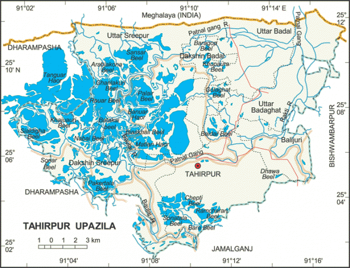

Tahirpur Upazila (Sunamganj district) with an area of 313.70 sq km, is bounded by Meghalaya State of India on the north, Jamalganj and Dharmapasha upazilas on the south, Bishwamvarpur on the east and Dharmapasha on the west. Noted rivers are Baulai, Patnal, Rakti, Jadukata, Panaigang, Lakhmachhara; Major depressions: Tanguar Haor, Matiar Haor, Pakertala Beel, Baluar Haor, Sangsar Haor.
The geographic coordinates of Tahirpur town are 25.0967665N 91.1762697Edegree. Tahirpur (Town) consists of one mouza. The area of the town is 4.13 sq km. It has a population of 6879; male 51.20%, female 48.80%; density of population is 1666 per sq km. Literacy rate among the town people is 34.6%.
Tahirpur thana, now an upazila, was established in 1924. It consists of 7 union parishads, 136 mouzas and 239 villages.
Archaeological heritage Remnants of the residence of Raja Bijoy Singh (16th century).
Religious institutions Mosque 38, temple 7, church 1, place of pilgrimage 1, tomb 3.
As of 1991 Bangladesh census, Population 133569; male 51.67%, female 48.33%; Muslim 78.22%, Hindu 19.86%, Christian 1.03%, ethnic nationals (Garo and Hajang) 0.89%.
Literacy and educational institutions Average literacy 17.2%; male 22.5%, female 11.4%. Educational institutions: college 2, secondary school (government) 1, secondary school (private) 5, primary school (government) 28, primary school (private) 16, madrasa 8.
Main occupations Agriculture 45.19%, fishing 2.42%, agricultural labourer 26.10%, wage labourer 6.39%, commerce 7.86%, service 2.67%, others 9.37%.
Land control Among the peasants, 46% are landless, 12% marginal, 26% small, 12% intermediate and 4% rich.
Fisheries, dairies, poultries Fishery 8, dairy 41, poultry 39.
Communication facilities Roads: pucca 0.5 km and mud road 89 km.
Traditional transport Palanquin, bullock cart. These means of transport are extinct or nearly extinct.
Cottage industries Weaving 200, bamboo work about 340, goldsmith 45, blacksmith 64, potteries 135, welding 2.
Mineral resources Limestone, peat.
NGO activities brac, asa, grameen bank.
Health centres Upazila health centre 1, family planning centre 7, satellite clinic 1.
Nearby cities:
Coordinates: 25°5'45"N 91°10'35"E
- Dhobaura Upazila 85 km
- Gafargaon Upazila 95 km
- Kapashia Upazila 116 km
- Rupganj Upazila 142 km
- Keraniganj Upazila 177 km
- Matlab Upazila (North) Area 188 km
- Lohajang Upazila 198 km
- Patiya Upazila (পটিয়া) 312 km
- Chandanaish Upazila 323 km
- Banshkhali Upazila (বাঁশখালী উপজেলা) 331 km
- Tanguar Haor (wetland) Complex 10 km
- Dharmapasa Upazila 15 km
- Sunamganj District 25 km
- Dekar haor 29 km
- Mohangonj Upazila 34 km
- dingasuta Haor 35 km
- Khaliajuri Upazila 45 km
- Meghalaya 51 km
- Sylhet Division 80 km
- Dhaka Division 135 km