D-Day Artillery Emplacement StP75 3
France /
Basse-Normandie /
Saint-Pierre-du-Mont /
pointe du Hoc
World
/ France
/ Basse-Normandie
/ Saint-Pierre-du-Mont
France / World / Basse-Normandie / Calvados / Bayeux / Isigny-sur-Mer
Second World War 1939-1945, fortification, deck, gun emplacement
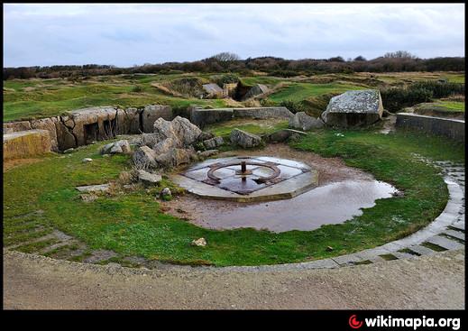
German WW2 Bunker for Point du Hoc, Stützpunkt 75
Open Emplacement for 155 mm type K418. These include the ammo storage
Part of a Pointe du Hoc memorial, left in original condition.
Sources:
www.atlantikwall.org.uk/point_du_hoc.htm
bunkersite.com/locations/france/normandie/pdh-open.php
IGN – star – Map scale 25 000°
Open Emplacement for 155 mm type K418. These include the ammo storage
Part of a Pointe du Hoc memorial, left in original condition.
Sources:
www.atlantikwall.org.uk/point_du_hoc.htm
bunkersite.com/locations/france/normandie/pdh-open.php
IGN – star – Map scale 25 000°
Wikipedia article: https://en.wikipedia.org/wiki/Pointe_du_Hoc
Nearby cities:
Coordinates: 49°23'45"N -0°59'15"E
- Emplacement StP75 4 0.1 km
- Emplacement StP75 2 0.1 km
- Bunker StP75 11 0.1 km
- D-Day german Bunker StP75 3 0.2 km
- Emplacement StP75 1 0.2 km
- German Command Bunker 0.2 km
- Pointe du Hoc 0.5 km
- Pointe Du Hoc Guns 1 km
- Wreck of USS LST-496 16 km
- Wreck of USS Susan B. Anthony (AP-72) 21 km
- Pointe du Hoc 0.1 km
- D-Day German R694 bunker StP75 3 0.1 km
- German Command Bunker R636 0.2 km
- Camperstop 3.8 km
- Ranger Memorial 4 km
- Rangers museum 4.1 km
- Memorial 4.4 km
- Charlie Sector 6.4 km
- DOG green sector 6.8 km
- The Sesame (Wreck) 8.9 km