Dowarabazar Upazila HQ
Bangladesh /
Sunamganj /
Chhatak /
World
/ Bangladesh
/ Sunamganj
/ Chhatak
World / Bangladesh / Sylhet / Sylhet / Sun Amgonj
township, subdistrict, fourth-level administrative division, local government
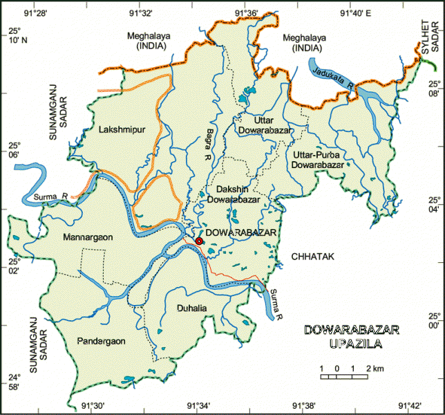
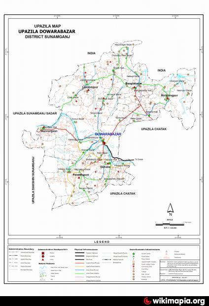
Dowarabazar Upazila (Sunamganj district) with an area of 281.4 sq km, bounded by Meghalaya state of India on the north, Chhatak upazila on the south and east, Sunamganj sadar upazila on the west. Main rivers are Surma, Jadukata and Bagra.
The geographic coordinates of Dowarabazar town are 25.0463887N 91.5580446E degree. Dowarabazar (Town) consists of consists of one mouza. It has an area of 4.46 sq km. The town has a population of 5171; male 53.37%, female 46.63%; density of population is 1159. Literacy rate among the town people 25.4%.
Dowarabazar thana, now an upazila, was established in 1976. It consists of 7 union parishads, 166 mouzas and 294 villages.
Religious institutions Mosque 15, temple 3, tomb 1.
As of 1991 Bangladesh census, Population 157240; male 50.74%, female 49.26%; Muslim 83.4%, Hindu 14.2%, Christian 0.5% and ethnic nationals (Monipuri) 1.9%.
Literacy and educational institutions Average literacy 15.6%; male 21%, female 10%. Educational institutions: college 1, high school 11, primary school (government) 28, primary school (private) 14, madrasa 12, Aambari High School, Ghilachhara Secondary High School, Barkhal Public High School, etc are notable institutions.
Main occupations Agriculture 50.20%, fishing 3.85%, agricultural labourer 22.21%, wage labour 5.22%, commerce 6.42%, service 1.74%, others 10.36%.
Land control Among the peasants 45.27% are landless, 13.7% marginal, 17% small, 17% intermediate and 7.03% rich.
Fisheries, dairies, poultries Fishery 2, dairy 24, poultry 64.
Communication facilities Roads: pucca 3 km and mud roads 122 km.
Cottage industries Weaving 200, goldsmith 24, blacksmith 39, welding 2.
Mineral resources Limestone.
NGO activities Grameen Bank.
Health centres Upazila health centre 1, family planning centre 7.
Nearby cities:
Coordinates: 25°2'42"N 91°33'35"E
- Dhobaura Upazila 124 km
- Gafargaon Upazila 125 km
- Kapashia Upazila 139 km
- Rupganj Upazila 159 km
- Keraniganj Upazila 196 km
- Matlab Upazila (North) Area 199 km
- Lohajang Upazila 215 km
- Patiya Upazila (পটিয়া) 300 km
- Chandanaish Upazila 310 km
- Banshkhali Upazila (বাঁশখালী উপজেলা) 320 km
- duhalia west 3.1 km
- dharma pur 3.8 km
- Dekar haor 12 km
- Ryngku 13 km
- SURMA River 13 km
- Abdullapur - Dariabad 14 km
- Sunamganj District Town 16 km
- Sunamganj District 26 km
- Sylhet Division 54 km
- Meghalaya 59 km