Austin Executive Airpark (3R3) (Austin, Texas)
USA /
Texas /
Wells Branch /
Austin, Texas
World
/ USA
/ Texas
/ Wells Branch
World / United States / Texas
airport
Add category
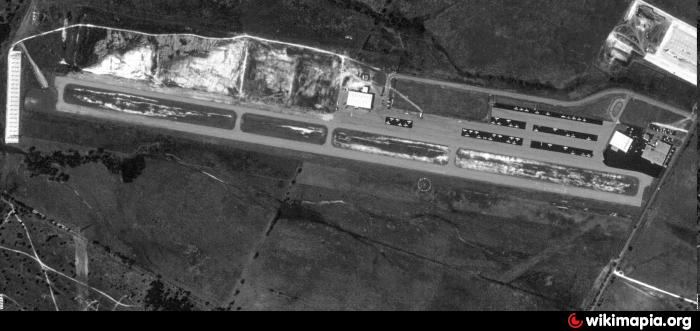
Not to be confused with the current nearby Austin Executive Airport, the Austin Executive Airpark was a former public-use airport located in North-Central Austin. The airport closed on May 1, 1999, after the property was purchased by Dell Computers. Only about 1,590 ft (489m) of runway and terminal remain intact, with other areas having since been removed and replaced with new warehouse facilities.
www.birdsnestaviation.com/
www.txdot.gov/publications/aviation/directory/6r4.pdf
www.airnav.com/airport/KEDC
Formerly Tim's Airpark (6R4)
Name: Austin Executive Airpark
IATA: 3R3
ICAO: K3R3
Austin , Texas United States
Latitude: 30°24' 49" N
Longitude: 97°39' 54" W
Elevation: 762
Runway 13/31
RY 13/31 CLSD INDEFLY.
Dimensions: 6025 x 100 feet
Surface: Asphalt in Good Condition
Weight Limits: D-90
Edge Lighting: Medium Intensity
MIRL OTS INDEFLY.
Runway 13 Runway 31
Coordinates: 30°24'12.98"N / 97°34'24.45"W 30°23'33.52"N / 97°33'32.86"W
Elevation: 620.0 596.6
Runway 16/34
Dimensions: 1550 x 25 feet
Surface: Asphalt in Fair Condition
Weight Limits: S-8
Runway 16 Runway 34
Coordinates: 30°23'49.58"N / 97°34'2.56"W 30°23'34.68"N / 97°33'58.28"W
Elevation: 615.0 599.3
skyvector.com/airport/EDC/Austin-Executive-Airport
LandisReed.
Nearby cities:
Coordinates: 30°24'43"N 97°39'57"W
- Austin-Bergstrom International Airport (AUS/KAUS) 22 km
- Killeen-Fort Hood Regional Airport (GRK/KGRK) 77 km
- New Braunfels Municipal Airport (KBAZ) 86 km
- Draughon-Miller Central Texas Regional Airport (TPL/KTPL) 87 km
- Randolph AFB Auxiliary Field/Seguin Field (KSEQ/SEQ) 96 km
- Texas A&M University RELLIS Campus 115 km
- McGregor Municipal Airport (KPWG) 125 km
- Easterwood Airport (CLL/KCLL) 126 km
- Waco Regional Airport 141 km
- TSTC Waco Airport (CNW/KCNW) 149 km
- Walnut Creek Park 2.5 km
- Copperfield 2.8 km
- Wells Branch, Texas 4.1 km
- Samsung Austin Semiconductor 5 km
- North Austin Civic Association 6.1 km
- Gateway 7.5 km
- Wooten 7.9 km
- North Shoal Creek 8.3 km
- Travis County 14 km
- Williamson County 28 km
Comments