Fort Carroll Light
| lighthouse, wooden
USA /
Maryland /
Riviera Beach /
World
/ USA
/ Maryland
/ Riviera Beach
World / United States / Maryland
lighthouse, wooden


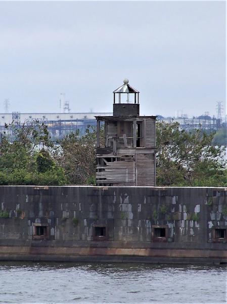

Fort Carroll Light is a lighthouse consisting of a short wooden tower on the walls of its namesake fortifications in the Patapsco River. It was constructed in 1854 and at the time, the light keeper was the only resident of the artificial (man made) island.
Wikipedia article: http://en.wikipedia.org/wiki/Fort_Carroll_Light
Nearby cities:
Coordinates: 39°12'52"N 76°31'11"W
- Fourteen Foot Bank Lighthouse 117 km
- Miah Maul Range Lighthouse 118 km
- Brandywine Shoal Light 123 km
- Harbor of Refuge Light and Outer Wall 129 km
- Wolf Trap Lighthouse 205 km
- Cape Hatteras Lighthouse Nation Historic Park 449 km
- Fort Dade / Egmont Key 1416 km
- Alligator Reef Light 1644 km
- former site of Northwest Passage light 1701 km
- Rebecca Shoal Lighthouse 1725 km
- Sparrows Point Shipyard/Former site of Bethlehem Sparrows Point Shipyard 2 km
- Cox Creek Dredged Material Containment Facility & Swan Creek Conservation Area 2.5 km
- Sparrows Point Terminal (formerly RG Steel/Sparrows Point Steel Mill) 3.7 km
- Brandon Shores and H. A. Wagner Generating Plants 3.9 km
- Edgemere, Maryland 5.2 km
- Tanyard Springs (Planned Community) 5.8 km
- Dundalk, Maryland 5.8 km
- Riviera Beach, Maryland 6 km
- Baltimore County, Maryland 25 km
- Anne Arundel County, Maryland 28 km
Sparrows Point Shipyard/Former site of Bethlehem Sparrows Point Shipyard
Cox Creek Dredged Material Containment Facility & Swan Creek Conservation Area
Sparrows Point Terminal (formerly RG Steel/Sparrows Point Steel Mill)
Brandon Shores and H. A. Wagner Generating Plants
Edgemere, Maryland
Tanyard Springs (Planned Community)
Dundalk, Maryland
Riviera Beach, Maryland
Baltimore County, Maryland
Anne Arundel County, Maryland