Bucks County Administration Building
USA /
Pennsylvania /
New Britain /
East Court Street, 55
World
/ USA
/ Pennsylvania
/ New Britain
World / United States / Pennsylvania
administrative building, local government
Formerly known as the Bucks County Courthouse until the completion of the Bucks County Justice Center next door.
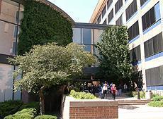
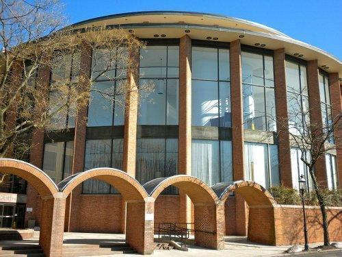
Home of the Bucks County Court of Common Pleas, and various county offices.The Courthouse (1962). Three successive courthouses have occupied the present site; the first one rather resembling a house. It was replaced in 1878, and again in 1962 by the present building.
The basic shape of this courthouse is best summed up by Williams: "It is really two buildings, consisting of a round and rectangular part. Airline pilots viewing it from the air have dubbed it 'the toilet'." This is a building, or rather buildings, in the Modern style with some architectural distinction. Perhaps if it sticks around age will confer some more, as circular public buildings are rare because of the additional cost and inefficient use of space.
The courtrooms are in the round part and offices in the rectangle. The two are connected by an enclosed hallway; entrance is into this hallway.
www.mapsofpa.com/countyseatsa.htm
www.buckscounty.org/courts/index.aspx
55 East Court Street, Doylestown, PA
Wikipedia article: http://en.wikipedia.org/wiki/Bucks_County,_Pennsylvania
Nearby cities:
Coordinates: 40°18'44"N 75°7'47"W
- Lawrence Square Village 39 km
- Beacon Hill 49 km
- Bridal Club 49 km
- Vanderhaven Farms Village I 49 km
- Willistown Woods 50 km
- High Point Camp and Conference Center 63 km
- Buena Vista Conference and Reception Center 87 km
- William J. Hughes Federal Aviation Administration Test & Research Facility 108 km
- Cold Spring Harbor Laboratory Banbury Center 154 km
- Babylon Town Hall 155 km
- Doylestown, Pennsylvania 0.3 km
- Doylestown Township 1.4 km
- None Such Farm 6 km
- Buckingham Township 6.3 km
- Lookaway Golf Club 6.8 km
- Warrington Township 7.8 km
- Warwick Township 8.3 km
- Palomino Farms 8.4 km
- Northampton Township 16 km
- Montgomery County, Pennsylvania 22 km
Comments