The castle of Ali Pasha
Greece /
Kerkira /
Kassiypi /
World
/ Greece
/ Kerkira
/ Kassiypi
, 9 km from center (Κασσιόπη)
World / Albania / Vlorë / Sarandës
castle
Add category


Following its capture from the French in 1798, the land around Butrint fell under the imperial estates of the Ottoman Empire and remained ‘Turkish’ until 1912. The most prominent Ottoman agent in the area at the time was the notorious Ali Pasha of Tepelena (1741-1822).
Ali Pasha constructed a series of redoubtable fortresses as his territory grew, most notably at Tepelena, Gjirokastra, Ioannina – where he made his capital – as well as at Lëkurës, a few miles to the north of Butrint on hills overlooking modern Saranda. Feted for bringing renewed prosperity to Epirus, he entertained a series of notable Western emissaries; the poet Lord Byron recorded his encounter with Ali Pasha in 1809 in his work Childe Harold’s Pilgrimage.
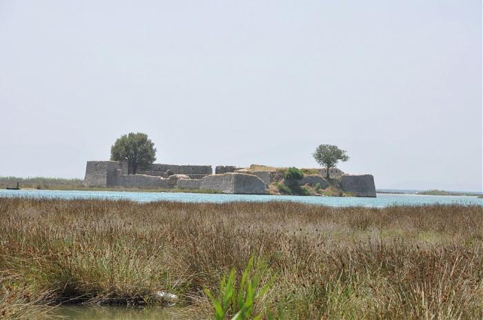
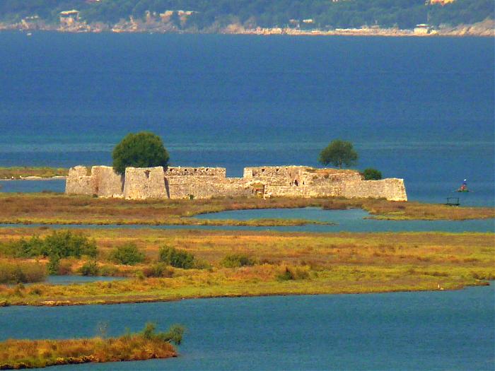
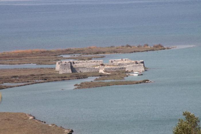
A small fortress at the mouth of the Vivari Channel has often been attributed to Ali Pasha, although it appears on the Venetian cadastral map of 1718 and may have been the possession of the Corfiot Gonemi family.
The channel-mouth fort as it stands is a small rectangular structure (22 x 30 m) with battered walls. The earliest building within the later fort is a large rectangular tower supported by three barrel-vaulted rooms. The main area of occupation would have been in the upper levels of the tower (now destroyed). Around this tower is a later circuit wall. The Vivari Channel fort’s circuit includes two battered round towers with firing embrasures on its seaward side and two irregularly sized battered square towers, again with firing loops or windows, looking up the channel towards Butrint.
The principal entrance of the fort lay beneath the former dwelling space to the north, where the central vaulted chamber, protected by musket ports, opened directly onto the Vivari Channel; it is fair to assume that in this phase the fort functioned as a small naval base, with its central area filled with water and steps leading up to parapet level. The parapet ran around three sides of the fort and provided cannon platforms. The south wall has comparatively fewer firing loops than elsewhere, largely because of two arched garderobes, with rails for screens and chutes out into the extramural area and a central low arch with a similar chute, perhaps for slops; there is also a circular firing loop adjacent to the southwest corner tower.
In c. 1808 Ali Pasha secretly requested military assistance from the English against the French, and Foreign Secretary George Canning duly instructed Lt. Col. William Martin Leake to present Ali with artillery pieces in a bid to unite all the Albanian chiefdoms against the French. Consequently, by 1819 the fortified castle with its battery of guns was able to exchanged salutes with the British Naval 40 gun frigate HMS Glasgow.
www.youtube.com/watch?v=TWxDdoVZRqg
Ali Pasha constructed a series of redoubtable fortresses as his territory grew, most notably at Tepelena, Gjirokastra, Ioannina – where he made his capital – as well as at Lëkurës, a few miles to the north of Butrint on hills overlooking modern Saranda. Feted for bringing renewed prosperity to Epirus, he entertained a series of notable Western emissaries; the poet Lord Byron recorded his encounter with Ali Pasha in 1809 in his work Childe Harold’s Pilgrimage.
A small fortress at the mouth of the Vivari Channel has often been attributed to Ali Pasha, although it appears on the Venetian cadastral map of 1718 and may have been the possession of the Corfiot Gonemi family.
The channel-mouth fort as it stands is a small rectangular structure (22 x 30 m) with battered walls. The earliest building within the later fort is a large rectangular tower supported by three barrel-vaulted rooms. The main area of occupation would have been in the upper levels of the tower (now destroyed). Around this tower is a later circuit wall. The Vivari Channel fort’s circuit includes two battered round towers with firing embrasures on its seaward side and two irregularly sized battered square towers, again with firing loops or windows, looking up the channel towards Butrint.
The principal entrance of the fort lay beneath the former dwelling space to the north, where the central vaulted chamber, protected by musket ports, opened directly onto the Vivari Channel; it is fair to assume that in this phase the fort functioned as a small naval base, with its central area filled with water and steps leading up to parapet level. The parapet ran around three sides of the fort and provided cannon platforms. The south wall has comparatively fewer firing loops than elsewhere, largely because of two arched garderobes, with rails for screens and chutes out into the extramural area and a central low arch with a similar chute, perhaps for slops; there is also a circular firing loop adjacent to the southwest corner tower.
In c. 1808 Ali Pasha secretly requested military assistance from the English against the French, and Foreign Secretary George Canning duly instructed Lt. Col. William Martin Leake to present Ali with artillery pieces in a bid to unite all the Albanian chiefdoms against the French. Consequently, by 1819 the fortified castle with its battery of guns was able to exchanged salutes with the British Naval 40 gun frigate HMS Glasgow.
www.youtube.com/watch?v=TWxDdoVZRqg
Wikipedia article: http://en.wikipedia.org/wiki/Ali_Pasha_Castle
Nearby cities:
Coordinates: 39°44'29"N 19°59'32"E
- Fortress Forest 35 km
- Castle of Ioannina 74 km
- Kastri Rizovouni - Ancient Vatiae 91 km
- Fortress Assos 158 km
- The ancient citadel (Acropolis) in the position of Island of Lake Xynias in the limits of the Village Koromilia 210 km
- Nafpaktos castle 218 km
- Akova Castle 284 km
- Mystras 362 km
- restos del castillo fortaleza de san felipe de mahon 1340 km
- Tamentfoust(La perouse) 1499 km
- Ishulli Jugor i Vivarit 0.2 km
- Bay of Butrint 1.1 km
- Vivari Channel 1.6 km
- Butrint 2.5 km
- Butrint National Park 3.2 km
- Corfu Channel 3.3 km
- Lake Butrint 5.4 km
- Sarandë District 18 km
- Corfu 20 km
- Peripheral unit of Thesprotia 38 km