Ishurdi Upazila HQ
Bangladesh /
Pabna /
Ishurdi /
World
/ Bangladesh
/ Pabna
/ Ishurdi
World / Bangladesh / Rajshahi / Pabna / Pabna
township, subdistrict, fourth-level administrative division, local government
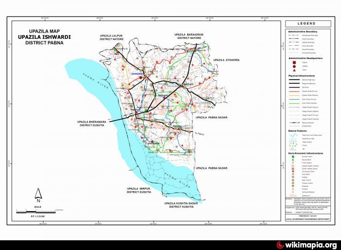
Ishwardi Upazila (Pabna district) with an area of 256.90 sq. km, is bounded by Lalpur and Baraigram upazilas on the north, Kushtia sadar and Mirpur (Kushtia) upazilas and the Ganges on the south, Pabna sadar and Atgharia upazilas on the east, Bheramara and Lalpur upazilas and Ganges river on the west. Main river is Ganges. Pati Beel is noted.
Ishwardi town is located at 24.1229305N 89.058545E. Ishwardi (Town) consists of 12 wards and 37 mahallas. The area of the town is 23.73 sq km. The town has a population of 63106; male 51.64%, female 48.36%. The density of population is 2659 per sq km. Literacy rate among the town people is 51.8%. Sugarcane Research Centre, Regional Agricultural Research Centre, Pulse Research Centre, Silk Seed Store and many industrial establishments are located in the town.
Ishwardi thana, now an upazila, was established in 1906. The upazila consists of one municipality, three wards, seven union parishads, 150 mouzas and 113 villages.
Archaeological heritage and relics: Three-domed Jami Mosque (Juktitala).
Historical events: The Hardinge Bridge, built on the Padma river in 1912 (renovated in 1972) is located at Ishwardi. The bridge is named after Michael Lord Hardinge and is 5940 feet long.
As of the 1991 Bangladesh census: Population 236825; male 51.88%, female 48.12%; Muslim 94.99%, Hindu 3.85% and others 1.16%; ethnic nationals: Marmi 187 families.
Religious institutions: Mosque 210, temple 12, church 3, pagoda 1, most noted of which Ishwardi Central Jami Mosque and Masjidul Fataha.
Literacy and educational institutions: Average literacy 35.5%; male 39.1% and female 31.6%. Educational institutions: college 7, agricultural college 1, vocational textile college 1, non-government cadet college 1, high school 26, girl's school 7, junior high school 8, vocational training institute 1, agricultural training institute 1, madrasa 21, government primary school 66, non-government primary school 28. Noted Educational institutions: Ishwardi Model Government Primary School (1932), Sara Marwari School (1917), Ishwardi Government College (1963), Majdia Islamia Senior Madrasa (1961).
Cultural organisations: Club 5, cultural organisation 7, youth welfare society 18, sports society 108, women's society 32, rural cooperative society 276, cinema hall 4, theatre stage 1, theatre group 2, literary society 3.
Main occupations: Agriculture 19.85%, agricultural labourer 17.11%, wage labourer 7.43%, commerce 19.17%, service 17.79%, hawker 2.13%, transport 2.64% and others 13.88%.
Land use: Total cultivable land 20254.96 hectares; single crop 70.75%, double crop 23.86% and treble crop 5.39%; land under irrigation 90%.
Land control: Among the peasants 38.45% are landless, 54.77% small, 5.35% intermediate and 1.43% rich.
Main crops: Paddy, wheat, sugarcane, betel leaf, potato, onion and brinjal.
Fisheries, dairies, poultries Dairy 57, poultry 45, fishery 12.
Communication facilities- Roads: pucca road 150 km, mud road 850 km; waterways 16 nautical mile; railways 40 km; railway station 3; airport 1.
Manufactories: Sugar mill 2, paper mill 1, cotton mill 1, cement factory 4, rice mill 400, flour mill 2, ice factory 5, saw mill 28, steel mill 1, cold storage 2.
Cottage industries: Weaving 35, jute and jute goods 10, bamboo work 50, blacksmith 70, goldsmith 45, potteries 55, wood work 810, bidi factory 3 and tailoring 500.
NGO activities: Operationally important NGOs are brac, ccdb, ITCL, Nova, Agro-foundation, Mauchak Bangla and the Door Bangladesh.
Health centres: Hospital 4, upazila health complex 1, family welfare centre 7 and charitable dispensary 3.
Nearby cities:
Coordinates: 24°7'41"N 89°3'53"E
- Sarishabari Upazila 104 km
- Abhaynagar Upazila HQ 122 km
- Gobindaganj Upazila 124 km
- Bholahat Upazila HQ 128 km
- Shaghatta Upazila 131 km
- Fakirhat Upazila HQ 160 km
- Kachua Upazila HQ 181 km
- Koyra Upzila HQ 195 km
- Maidi Vdc 604 km
- Samote Union Council 1837 km
- Bangladesh Agriculture and Dal Research Center 1.6 km
- Sugarcane Research & Training Istitute 2.7 km
- Iswardi Airport 3.2 km
- Siraj's Bari 4.2 km
- dasuria bazaar 6.2 km
- Rooppur NPP worksite 7.4 km
- Arkandi 12 km
- Rayta pathor ghat (bahadurpur) 14 km
- Rajshahi Division 122 km
- Khulna Division 139 km