Angels Flight (1901 - 1969 site) (Los Angeles, California)
USA /
California /
Vernon /
Los Angeles, California
World
/ USA
/ California
/ Vernon
World / United States / California
historical layer / disappeared object
Add category
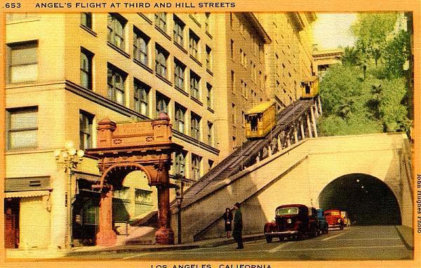
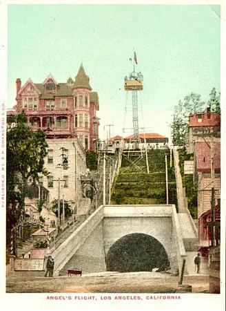


Angels Flight originally ascended Bunker Hill directly adjacent and south of Third Street. It was operation in this location from 1901 until 1969, when it was removed by the Community Redevelopment Agency (CRA) so that the hill originally located here could be levelled as part of the area's redevelopment.
Before the area was razed, numerous buildings could be found on either side of the funicular: the residential hotels Hillcrest and Astoria, on Olive Street; the Hulbert Apartment Hotel at 3rd and Clay; an 8-story Elks' Club building; and the 7-story Ferguson office building. The funicular also crossed over the now-gone Clay Street.
It was eventually restored in a new spot one half block south in 1996.
www.uncanny.net/~wetzel/subwayarea.htm#angel
www.ulwaf.com/LA-1900s/PicturePages/AngelsFlight3rdSt.h...
Crossing Clay St.: www.uncanny.net/~wetzel/clayat3rd.JPG
1909 shot showing the Flight in front of the former Elks' Club: www.uncanny.net/~wetzel/3rdClay.jpg
The Flight next to the Ferguson Bldg.: www.uncanny.net/~wetzel/angelsflight-8590.jpg
Wikipedia article: http://en.wikipedia.org/wiki/Angels_Flight
Nearby cities:
Coordinates: 34°3'7"N 118°14'58"W
- Hollywood Subway(former) 1.3 km
- 6th Street Viaduct (1932) 2.2 km
- Selig Movie Studio and Zoo 5 km
- Ascot Speedway 5.3 km
- Reservoir No. 5 5.6 km
- Defunct interchange 5.8 km
- Taylor Yard 6 km
- Metro Studios back lot-historical place 6.6 km
- Area used in making Halloween (1978) 11 km
- Former Glendale Airport / Grand Central Airport 14 km
- Bunker Hill 0.3 km
- Historic Core 0.4 km
- Grand Avenue Commercial District 0.4 km
- Financial District 0.6 km
- Civic Center 0.7 km
- Central City East (Skid Row) 1.1 km
- Downtown 1.2 km
- South Park 1.8 km
- Fashion District 1.8 km
- Westlake 2.4 km