Scoresbysund / Ittoqqortoormiit
| village
Greenland /
Illoqqortoormiut /
World
/ Greenland
/ Illoqqortoormiut
/ Illoqqortoormiut
World / Greenland / Tunu
village
Add category
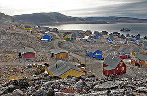
Ittoqqortoormiit (IPA: [itoqɔʁtɔʁmit], Danish: Scoresbysund) is a town in East Greenland. The town is located near the mouth of Kangertittivaq (Danish: Scoresby Sund). It is one of the most remote of Greenland's towns, only reachable by plane to Constable Pynt airport (two weekly departures from Iceland), and then with helicopter or by boat a few months a year.
Ittoqqortoormiit is also the administrative center of the Municipality of Ittoqqortoormiit which encompasses an area of 235,000 km² (91,000 sq mi) along the Denmark Strait and the Greenland Sea. Population is 537 (as of 2005). The place is known for its wildlife which includes polar bears, muskoxen, and seals.
The Danish name Scoresbysund derives from the name of the Arctic explorer and whaler William Scoresby, who was the first to map the area in 1822. The Greenlandic name Ittoqqortoormiit means "Big House".
Wikipedia article: https://en.wikipedia.org/wiki/Ittoqqortoormiit
Nearby cities:
Coordinates: 70°29'7"N 21°57'36"W
- Belakavadi Village 1143 km
- Illorsuit 1144 km
- ECHELON - Canadian Forces Station Alert 1626 km
- Alert, Nunavut 1628 km
- Clyde_River, Nunavut 1693 km
- Pond Inlet (Mittimatalik) 1911 km
- Pond Inlet 1911 km
- Arctic Bay 2116 km
- Igloolik 2197 km
- Repulse Bay 2531 km
- Ymer Island 315 km
- Clavering Ø 423 km
- Kangerlussuaq Fjord 462 km
- Sabine Island 469 km
- Kuhn Island 492 km
- Jan Mayen Island 496 km
- Beerenberg 507 km
- Shannon Island 537 km
- Danmarkshavn 658 km
- Helheim Glacier 808 km