Paikgacha Upazila HQ
Bangladesh /
Khulna /
Phultala /
World
/ Bangladesh
/ Khulna
/ Phultala
World / India / West Bengal / North 24 Parganas
township, subdistrict, fourth-level administrative division, local government
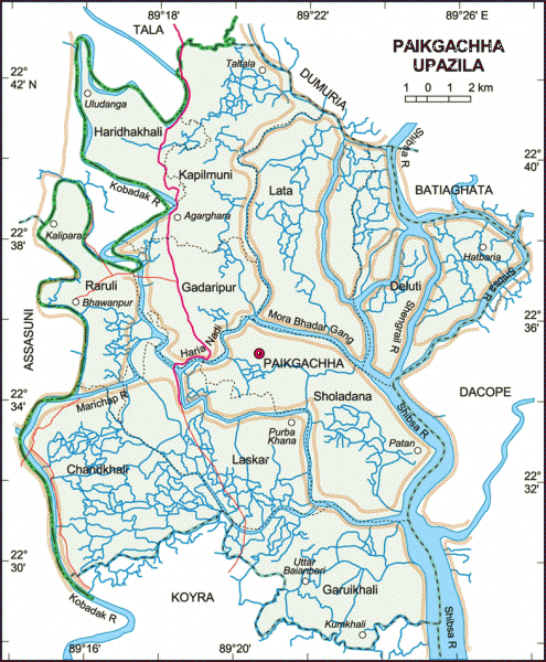
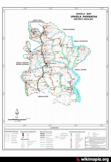
Paikgachha Upazila (Khulna district) with an area of 411.19 sq km, is bounded by Tala and Dumuria upazilas on the north, Koyra upazila on the south, Batiaghata and Dacope upazilas on the east, Tala and Assasuni upazilas on the west. Main rivers are Kobadak, Shibsa, Vadra. The Haria, Deluchi, Harrakhali, Narai, Gangkhali, Katakhai and Karulia are small rivers.
The location of the Paikgacha town is 22.5906553N 89.3178847E. Paikgachha (Town) consists of 9 wards and 5 mahallas. The area of the town is 2.12 sq km. The town has a population of 13656; male 52.54%, female 47.46%. Literacy rate among the town people is 46.7%. The density of population is 6442 per sq km. It has one dakbungalow.
Paikgachha thana was established in 1872 and was turned into an upazila in 1983. It consists of 10 union parishads, 171 mouzas, 212 villages.
Archaeological relics and monuments: Ancient remains and some dhibis.
As of the 1991 Bangladesh census: Population 225085; male 51.14%, female 48.86%; Muslim 63.51%, Hindu 35.01%, Christian 0.40%, Buddhist 1.04%, others 0.04%.
Religious institutions: Mosque 156, temple 54, church 3, sacred place 1.
Literacy and educational institutions: Average literacy 32.6%; male 43% and female 21.6%. college 6, secondary school 35, lower secondary school 13, madrasa 58, government primary school 74, non-government primary school 84, satellite school 11, women training institute 6.
Cultural organisations: Club 42, cinema hall 2, public library 1, children park 1, co operative society (women) 22, auditorium 1.
Main occupations: Agriculture 35.48%, forestry 1.49%, fishing and livestock 4.03%, agricultural labourer 19.33%, wage labourer 7.4%, service 3.41%, commerce 15.58%, transport 1.97%, industry 1.3%, others 10.01%.
Land use: Total cultivable land 30523.67 hectares, fallow land 485.22 hectares. Single crop 75.72%, double crop 18.82% and treble crop land 5.46%.
Land control: Among the peasants 34.78% are landless, 20.71% marginal, 23.51% intermediate and 21% rich.
Fisheries, dairies, poultries Hatchery 1, fishery 972, poultry 44, dairy 50, artificial breeding centre 1, carp nursery 4.
Communication facilities- Roads: pucca 30 km., semi pucca 100 km and mud road 465 km; waterways 15 nautical mile.
Manufactories: Handloom 2, jute and related industry 1, forest manufactory 6, tannery leather 1, engineering 4, oil mill 76, rice mill 37, fishing net 29, bakery 2.
Cottage industries: Mat and reeds 622, tailoring 163, wood work 102, dry fish 86, goldsmith 30, ironsmith 19, metal and handicraft 20, biri manufactory 6, gur (molasses) making 2, terracotta 10.
NGO activities: Satkhira Unnayan Sangstha (SUS), Uttoron, CSS, brac, asa, grameen bank, Mukulito Khulna.
Health centres: Upazila health complex 1, family planning centre 10, mother and child care centre 1, satellite clinic 7
Nearby cities:
Coordinates: 22°35'22"N 89°19'12"E
- Koyra Upzila HQ 24 km
- Fakirhat Upazila HQ 44 km
- Abhaynagar Upazila HQ 53 km
- Kachua Upazila HQ 56 km
- Sarishabari Upazila 253 km
- Bholahat Upazila HQ 288 km
- Gobindaganj Upazila 295 km
- Shaghatta Upazila 296 km
- Maidi Vdc 751 km
- Samote Union Council 1966 km
- Rampal Thermal Power Plant site 24 km
- Mongla Industrial Area 28 km
- E.P.Z 31 km
- MONGLA Miunicipality 32 km
- পাকখালী 33 km
- Khulna Division 35 km
- Sundarban Unon, Mongla Upazila 35 km
- Road of Sundarban union to Sadar upazila 38 km
- Joymoni 40 km
- Sundarbans 66 km