New Albany National Cemetery (New Albany, Indiana)
USA /
Indiana /
New Albany /
New Albany, Indiana
World
/ USA
/ Indiana
/ New Albany
World / United States / Indiana
cemetery
Add category
1943 Ekin Avenue
New Albany, IN 47150
Phone: (812) 948-5234
www.cem.va.gov/CEM/cems/nchp/newalbany.asp
New Albany National Cemetery is located New Albany, Ind., just across the Ohio River from Louisville, Ky. Founded just below the Falls of the Ohio, New Albany was first settled in the early 1800s by farmers who recognized the town’s potential as a transportation and ship-building hub. The first settlers in the region named the territory after the capital of their home state, New York. Prior to construction of the locks on the Louisville side of the river, New Albany was one of the largest cities in the Midwest due to its river location. Riverboat building and glass manufacturing were important industries. In 1858, Ashbel P. Willard, governor of Indiana and a New Albany resident, dedicated the Floyd County Fairground, and the following year the Indiana State Fair came to town. During the Civil War, the fairground was converted into Camp Noble where local regiments were mustered. New Albany became a strategic supply and training center for the Union troops fighting in the South, and a hospital center for the wounded being sent north, as well as part of the Underground Railroad for slaves escaping from the South.
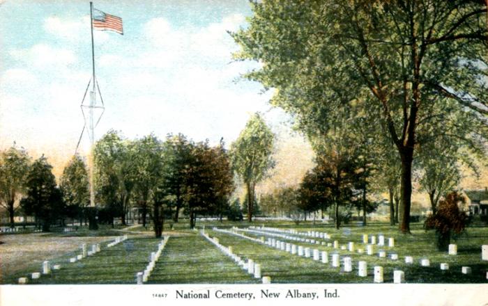
New Albany National Cemetery was established in 1862 to accommodate the burial of soldiers posted at the training center. It was also intended for the reinterment of Union soldiers who died in local hospitals and were buried in nearby gravesites and soldier’s plots. Most of the reinterments came from West Virginia, Virginia, Kentucky and Indiana. The original 5.5 acres were purchased from Dr. Charles Bowman in early 1862. By November 1870, more than 2,000 known dead and 698 unknowns were buried at New Albany. According to a 1870s inspection report, the African-American men of the U.S. Colored Troops were buried in segregated sections from their fellow soldiers.
Today a suburban residential community envelops the cemetery, which was placed on the National Register of Historic Places in 1999.
New Albany, IN 47150
Phone: (812) 948-5234
www.cem.va.gov/CEM/cems/nchp/newalbany.asp
New Albany National Cemetery is located New Albany, Ind., just across the Ohio River from Louisville, Ky. Founded just below the Falls of the Ohio, New Albany was first settled in the early 1800s by farmers who recognized the town’s potential as a transportation and ship-building hub. The first settlers in the region named the territory after the capital of their home state, New York. Prior to construction of the locks on the Louisville side of the river, New Albany was one of the largest cities in the Midwest due to its river location. Riverboat building and glass manufacturing were important industries. In 1858, Ashbel P. Willard, governor of Indiana and a New Albany resident, dedicated the Floyd County Fairground, and the following year the Indiana State Fair came to town. During the Civil War, the fairground was converted into Camp Noble where local regiments were mustered. New Albany became a strategic supply and training center for the Union troops fighting in the South, and a hospital center for the wounded being sent north, as well as part of the Underground Railroad for slaves escaping from the South.
New Albany National Cemetery was established in 1862 to accommodate the burial of soldiers posted at the training center. It was also intended for the reinterment of Union soldiers who died in local hospitals and were buried in nearby gravesites and soldier’s plots. Most of the reinterments came from West Virginia, Virginia, Kentucky and Indiana. The original 5.5 acres were purchased from Dr. Charles Bowman in early 1862. By November 1870, more than 2,000 known dead and 698 unknowns were buried at New Albany. According to a 1870s inspection report, the African-American men of the U.S. Colored Troops were buried in segregated sections from their fellow soldiers.
Today a suburban residential community envelops the cemetery, which was placed on the National Register of Historic Places in 1999.
Wikipedia article: http://en.wikipedia.org/wiki/New_Albany_National_Cemetery
Nearby cities:
Coordinates: 38°18'0"N 85°48'20"W
- St. Mary's Catholic Cemetery 1 km
- Fairview Cemetery 1.5 km
- Graceland Memorial Park 3 km
- Green Meadows Cemetery 12 km
- Louisville Memorial Gardens West 13 km
- Bethany Memorial Park and Cemetery 23 km
- Crown Hill Cemetery 43 km
- Mitchell Cemetery 77 km
- owensboro Memorial Gardens 122 km
- Rosehill-Elmwood Cemetery & Mausoleum 128 km
- Ohio River Greenway 2.9 km
- Portland neighborhood 3.7 km
- Shippingport Island 3.8 km
- Louisville and Portland Canal 4 km
- Shawnee neighborhood 4.2 km
- West End 5.1 km
- Lapping Park 5.2 km
- Floyds Knobs, Indiana 6.2 km
- Floyd County, Indiana 7.9 km
- Clark County, Indiana 18 km