Bhuapur Upazila HQ
Bangladesh /
Tangayal /
Gopalpur /
World
/ Bangladesh
/ Tangayal
/ Gopalpur
World / Bangladesh / Dhaka / Tangali / Tangail
township, subdistrict, fourth-level administrative division, local government
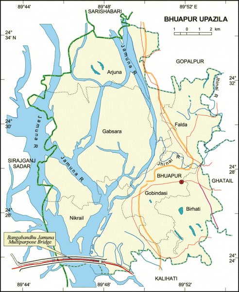
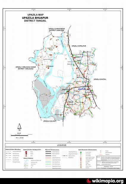
Bhuapur Upazila (Tangail district) with an area of 225.2 sq km, is bounded by Gopalpur and Sarishabari upazilas on the north, Kalihati upazila on the south, Kalihati, Ghatail and Gopalpur upazilas on the east and jamuna river and Sirajganj sadar on the west. Jamuna is the main river of the upazila.
The geographic coordinates of Bhuapur town are 24.4589999N 89.8743898E degree. Bhuapur (Town) a municipality, consist of 9 wards and 18 mahallas. It has an area of 3.30 sq km. The town has a population of 23705; male 50.22%, female 49.78%. The literacy rate among the town people is 51.9%.
The Bhuapur thana, now an upazila, was established in 1974. The upazila has one municipality, six union parishads, 115 mouzas and 146 villages.
Religious institutions: Mosque 50, temple 7, most noted Kismat Moria mosque.
As of 1991 Bangladesh census, Population 177009; male 51.7%, female 48.3%; Muslim 96.14%, Hindu 3.60%, Christian 0.09%, Buddhist 0.08% and others 0.09%.
Literacy and educational institutions: Average literacy 29.9%; male 36.9%, female 22.4%. Educational institutions: college 9, high school 28, madrasah 10.
Main occupations: Agriculture 53.8%, fishing 1.23%, agricultural labourer 17.4%, wage labourer 1.94%, commerce 9.39%, transport 1.57%, service 5.76%, others 8.91%.
Land control: Among the peasants 54% are landless, 33% small, 10% intermediate and 3% rich.
Fisheries, poultries Fishery 74, poultry 50.
Manufactories: Cotton mill 1, ice factory 3.
Cottage industries: Bamboo work, wood work, cane work.
NGO activities: Operationally important NGOs are brac, asa, SRDS, caritas and Barendra.
Health centres: Upazila health complex 1, satellite clinic 2, family planning centre 7.
Nearby cities:
Coordinates: 24°27'50"N 89°52'29"E
- Sarishabari Upazila 44 km
- Shaghatta Upazila 95 km
- Gobindaganj Upazila 109 km
- Abhaynagar Upazila HQ 164 km
- Bholahat Upazila HQ 179 km
- Fakirhat Upazila HQ 186 km
- Kachua Upazila HQ 199 km
- Koyra Upzila HQ 240 km
- Maidi Vdc 641 km
- Samote Union Council 1881 km
- Ghatail Cantonment 13 km
- Jamuna Bridge 13 km
- GFR 14 km
- Elenga 15 km
- Sirajgong District Town 18 km
- hashara 20 km
- Haluakandi 23 km
- Khukni 34 km
- Dhaka Division 60 km
- Rajshahi Division 125 km
Comments