Mount Bandila-an (Cang-agong)
Philippines /
Central Visayas /
Siquijor /
Cang-agong
World
/ Philippines
/ Central Visayas
/ Siquijor
World / Philippines / Siquijor / Siquijor
mountain, summit, invisible

Summit elevation 628 meters asl..
Siquijor, Philippines
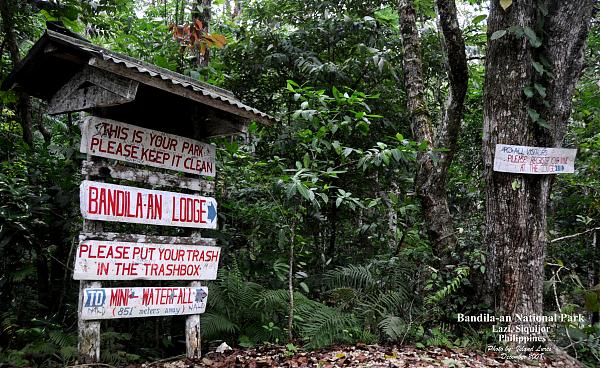
- Mount Bandila-an National Park -
www.youtube.com/watch?v=NWLX2wR2XPw
At 557 meters above sea level, Bandila-an National Park is the highest point in the Island of Siquijor. It is located almost centrally on the Island. It is accessible from almost all points around the Island but the best way is through a semi-paved road from the towns of Lazi, Larena and Siquijor.
For those who would like to get away from it all and enjoy quiet walks and fresh air, this is the best place to be. There are a few trails for hiking and a small rest area for those who would like to just take it easy and relax. The park is not very large and one can easily walk the trails and enjoy the sights in less than half a day. However, there are no guided tours and most visitors are basically on their own.
The Park is home to protected Flora and Fauna and is maintained by by the National Government. Like many in the country, because of its low budget and underpaid staff, maintenance of the park is at its bare minimum. There is no watchdog to monitor its environmental protection, which make it very vulnerable to unsupervised human intrusion and urban trash.
At the turn of the 20th century, because of uncontrolled poaching and hunting, many of the endemic wildlife, especially the larger species, have been wiped out to extinction... forever gone. There are however still a few of the smaller creeping and winged species but they are very rarely seen in the open.
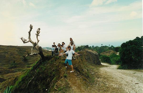
From a view point on the summit, one will enjoy a breathtaking 360 degrees vista of the Siquijor Island shoreline, including a view of the nearby Islands of Negros, Cebu, Bohol, Camiguin, Apo and Mindanao. - Limocon
Pictures courtesy of Island Lures. For more pictures of Mount Bandila-an, please visit: www.panoramio.com/user/1934556/tags/Mount%20Bandila-an .
Siquijor, Philippines
- Mount Bandila-an National Park -
www.youtube.com/watch?v=NWLX2wR2XPw
At 557 meters above sea level, Bandila-an National Park is the highest point in the Island of Siquijor. It is located almost centrally on the Island. It is accessible from almost all points around the Island but the best way is through a semi-paved road from the towns of Lazi, Larena and Siquijor.
For those who would like to get away from it all and enjoy quiet walks and fresh air, this is the best place to be. There are a few trails for hiking and a small rest area for those who would like to just take it easy and relax. The park is not very large and one can easily walk the trails and enjoy the sights in less than half a day. However, there are no guided tours and most visitors are basically on their own.
The Park is home to protected Flora and Fauna and is maintained by by the National Government. Like many in the country, because of its low budget and underpaid staff, maintenance of the park is at its bare minimum. There is no watchdog to monitor its environmental protection, which make it very vulnerable to unsupervised human intrusion and urban trash.
At the turn of the 20th century, because of uncontrolled poaching and hunting, many of the endemic wildlife, especially the larger species, have been wiped out to extinction... forever gone. There are however still a few of the smaller creeping and winged species but they are very rarely seen in the open.
From a view point on the summit, one will enjoy a breathtaking 360 degrees vista of the Siquijor Island shoreline, including a view of the nearby Islands of Negros, Cebu, Bohol, Camiguin, Apo and Mindanao. - Limocon
Pictures courtesy of Island Lures. For more pictures of Mount Bandila-an, please visit: www.panoramio.com/user/1934556/tags/Mount%20Bandila-an .
Nearby cities:
Coordinates: 9°11'26"N 123°35'0"E
- Mount Agumid 234 km
- Puno Mahaji 337 km
- Mount Sinumaan 445 km
- Mt. Peel, Palawan 544 km
- Mount Aborlan 566 km
- Victoria Peaks 583 km
- Escarpado Peak 687 km
- Constance Peak, Kalimantan Utara, Indonesia 855 km
- Castle Peak 915 km
- Mt. Liyang (1665 m) 1482 km
- Siquijor 1.7 km
- Sitio Langub 4.3 km
- Taculing/Cangmalalag Sanctuary 10 km
- Maria Bay 10 km
- Crocodile Hills 11 km
- Limestone Strip Mining 11 km
- Salagdong Forest 11 km
- Tulapos Marine Sanctuary 13 km
- Cebu Strait 69 km
- Cebu 138 km