West Kirby Beacon (West Kirby)
United Kingdom /
England /
Hoylake-West Kirby /
West Kirby
World
/ United Kingdom
/ England
/ Hoylake-West Kirby
World / United Kingdom / England
daymark / daybeacon
Add category
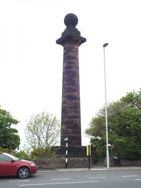
The Beacon stands on the site of an old mill that was used as a landmark by mariners navigating into the River Mersey. It was destroyed in a storm in 1839 and the present 60ft (18m) column was erected in 1841 by the trustees of the Liverpool Docks by permission of the landowner John Shaw Leigh, who also gave the stone for its construction.
Nearby cities:
Coordinates: 53°22'14"N 3°10'12"W
- Brownstown Day Markers 299 km
- Metal Man Day Markers 303 km
- Gwennap Head Daymarks (Black & Red) 409 km
- Grand Amfroque beacons 433 km
- Crookhaven Light 495 km
- MOA Cayo Moa Grande light 6981 km
- Hen and Chicken Shoals light 6995 km
- ISLA PICUDA CHICA Light 7221 km
- PUERTO CABELLO Warship Quay SE 7425 km
- PUERTO CABELLO Fortin Solano 7428 km
- West Kirby Marine Lake 1.1 km
- Hoylake Municipal Golf Course 1.7 km
- Royal Liverpool Golf Course 1.9 km
- Caldy Golf Club 2.3 km
- Wirral Peninsula 8 km
- Point of Ayr RSPB Nature reserve 10 km
- Presthaven Sands 13 km
- Burbo Wind Farm 15 km
- Merseyside 19 km
- North Hoyle Offshore Wind Farm 20 km