Nabinagar Upazila HQ
Bangladesh /
Brahman Bariya /
Nabinagar /
World
/ Bangladesh
/ Brahman Bariya
/ Nabinagar
World / Bangladesh / Chittagong / Comilla / Brahmanbaria
township, subdistrict, fourth-level administrative division, local government
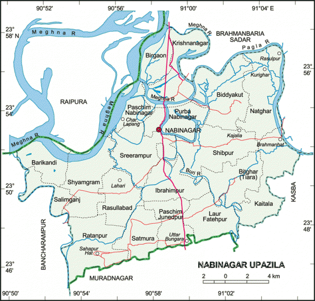
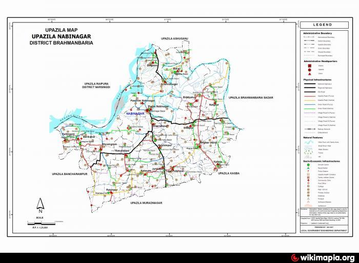
Nabinagar Upazila (Brahmanbaria district) with an area of 353.66 sq km, is bounded by Brahmanbaria sadar and Raipura upazilas on the north, Muradnagar upazila on the south, Kasba and Brahmanbaria Sadar upazilas on the east, Bancharampur and Raipura upazilas on the west. Main rivers are Meghna, Pagla and Buri; Bagdahar Beel is noted.
The location of the Nabinagar town is 23.887442N 90.9686637E. Nabinagar (Town) consists of 9 wards and 18 mahallas. The area of the town is 8.28 sq km. It has a population of 40777; male 49.81%, female 50.19%; population density per sq km 4925. Literacy rate among the town people is 45.9%.
Nabinagar thana was turned into an upazila in 1983. The upazila consists of 19 union parishads, 155 mouzas and 198 villages.
As of the 1991 Bangladesh census: Population 378539; male 50.56%, female 49.44%; Muslim 90.52%, Hindu 9.27% and others 0.21%.
Religious institutions: Mosque 500, temple 30, Sarva Dharma Mission 2, most noted of which are Registry Office Jami Mosque, Shah Saheb Bari Mosque.
Literacy and educational institutions: Average literacy 27.4%; male 32.6% and female 22%. Educational institutions: college 4, high school 25, madrasa 8, government primary school 144, non-government primary school 55. Noted educational institution: Nabinagar Pilot High School (1896), Kuti Atal Bihari High School (1918).
Cultural organisations: Club 34, public library 1, press club 1, cinema hall 4, shilpakala academy 1, playground 25.
Main occupations: Agriculture 43.52%, agricultural labourer 20.48%, wage labourer 3.06%, commerce 13.32%, service 6.96%, fishing 2.1% and others 10.56%.
Land use: Total cultivable land 28773.78 hectares; fallow land 6870.9 hectares; single crop 53.12%, double crop 41.05% and treble crop land 5.83%. Land under irrigation 37.29%.
Fisheries, dairies, poultries Poultry 20, fishery 50, hatchery 6 and artificial breeding centre 5.
Communication facilities- Roads: pucca 13 km, semi pucca 12 km and mud road 455 km; waterways 56 nautical mile.
Manufactories: Saw mill 30, ice factory 8.
Cottage industries: Cottage industries include bamboo work, goldsmith, blacksmith, wood work, potteries, tailoring, etc.
NGO activities: Operationally important NGOs are asa, brac, proshika, Hope.
Health centres: Upazila health complex 1, health and family welfare centre 13, union family planning clinic 5, red cross maternity 1, satellite clinic 7.
Nearby cities:
Coordinates: 23°53'4"N 90°58'8"E
- Rupganj Upazila 44 km
- Matlab Upazila (North) Area 59 km
- Kapashia Upazila 65 km
- Keraniganj Upazila 75 km
- Lohajang Upazila 85 km
- Gafargaon Upazila 90 km
- Dhobaura Upazila 159 km
- Patiya Upazila (পটিয়া) 190 km
- Chandanaish Upazila 204 km
- Banshkhali Upazila (বাঁশখালী উপজেলা) 210 km
- Charlapang 4.7 km
- Ateem khana 6.6 km
- shah jalal village 6.9 km
- kagolia 7.7 km
- jafar pur gram 8 km
- satmura paddy field 11 km
- shimrial Uttor Parra 13 km
- Korbanpur 18 km
- Narsingdi District 25 km
- Dhaka Division 70 km
Comments