Anak Kinabalu / Nungkok
Malaysia /
Sabah /
Ranau /
Tamparuli - Ranau Highway
World
/ Malaysia
/ Sabah
/ Ranau
World / Malaysia / Sabah
mountain
Add category

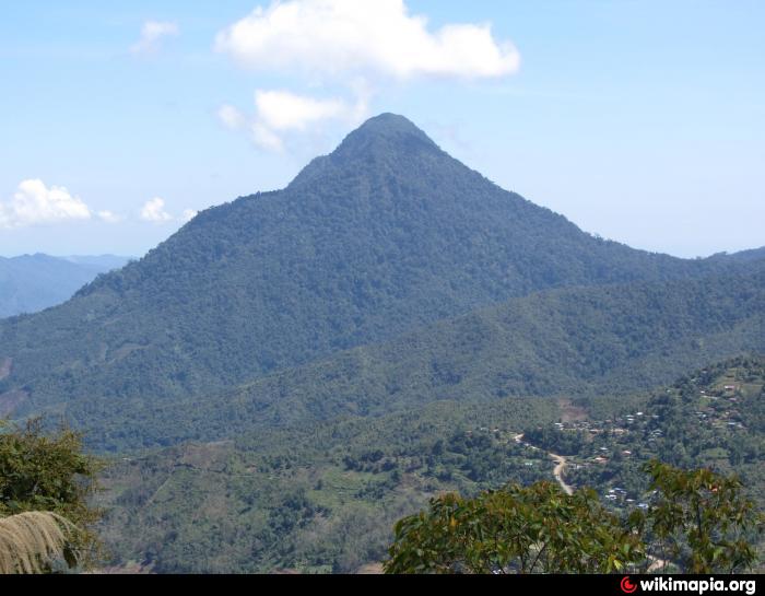

Known also as the Child of Kinabalu, Nungkok is a mountain located on the western foothills of Mount Kinabalu near Kota Belud. The given name is used by the native people of the nearby villages. It is about three times lower than Mount Kinabalu. The best place to see the mountain is from Kota Belud (best location is Tambatuon Village), Pekan Nabalu or on the way to Kinabalu National Park. It cannot be seen from Kundasang, Ranau or Kota Kinabalu. So far not many have heard about this mountain, but ask the locals around there and they'll know it.
On days when Mount Kinabalu is obscured by mist and clouds, it is not uncommon for first-timers on the Tamparuli Ranau Highway to mistake this as Mount Kinabalu. As one is traveling along this highway from Tamparuli, the first angle of this mountain is its front (western) slopes. A small portion of granite rock is also visible near the peak of this mountain. As one ascends nearer to Kinabalu National Park, the appearance of this mountain slowly changes from 'oblong-shaped' to 'pyramid with a blunt peak' shape. Some research has it that there are even deposits of copper, molybdenum, tungsten and nickel around the vicinity of the mountain.
On February 17th, 2017, a group of hikers from Sabah Parks and Tambatuon were the first notable group to hike up this mountain. The trail to the peak the mountain is still unheard of, but it spans for about 3km. It was discovered that Mt. Nungkok peaked out at 1651 metres a.s.l.
Nearby cities:
Coordinates: 6°6'4"N 116°28'29"E
- Mount Kinabalu 10 km
- Mount Tambuyukon 23 km
- Mount Alab 32 km
- Gunung Monkobo 58 km
- Castle Peak 59 km
- Gunung Mentapok 62 km
- Kampung Bingolon Kudat 84 km
- Bukit Bidu Bidu 88 km
- Mount Mondugon 322 km
- Mount Mantalingajan 331 km
- TMBT 5ok 5.2 km
- Dongkulas 7.1 km
- Kg Balabakan Lama 9 km
- Kampung Pantok Kiulu 12 km
- Nadau 12 km
- Kinabalu Park 13 km
- KAMPUNG RUNGUS KIULU 14 km
- Tenompok Forest Reserve 14 km
- Kinabalu Park 16 km
- Ranau District 42 km