Operation: Reality Check hurricane pole 3 of 41 (Neptune Beach, Florida)
| floodlevel sign
USA /
Florida /
Atlantic Beach /
Neptune Beach, Florida
World
/ USA
/ Florida
/ Atlantic Beach
World / United States / Florida
floodlevel sign
Add category
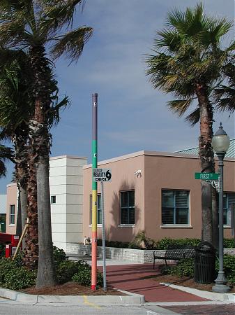
"Operation: Reality Check" helps Duval County residents who live in a storm surge zone know their evacuation status and encourages them to have a personal and family disaster plan. Poles have been placed around the county in highly visible areas, showing the maximum height of storm surge at each hurricane category level. Storm surge is the abnormal rise in water level caused by wind and pressure forces of a hurricane or tropical storm. Levels represented here are the "maximum of maximums."
www.coj.net/Departments/Fire+and+Rescue/Emergency+Prepa...
www.coj.net/Departments/Fire+and+Rescue/Emergency+Prepa...
Nearby cities:
Coordinates: 30°19'25"N 81°23'45"W
- Operation: Reality Check Hurricane Pole 4 of 41 1.1 km
- Flood height marker 1541 km
- Dyke Collapse Memorial 7126 km
- Wateringse Sluis 7128 km
- Monsterse Sluis 7128 km
- Smeepoort 7203 km
- Havenkade 33 7214 km
- Cafe Kandinsky 7236 km
- Flood Level Sign (Koblenz) 7405 km
- Saint Rókus chapel 8299 km
- "Old Atlantic Beach" 1.1 km
- Kathryn Abbey Hanna Park 5.3 km
- Villages of Pablo Subdivision 5.5 km
- Queen's Harbor 5.7 km
- The Woods Subdivision 6.6 km
- Naval Station Mayport (NRB/KNRB) 7.2 km
- Grogan's Bluff Neighborhood 7.3 km
- Kensington Subdivision 8.2 km
- The Theodore Roosevelt Area (aka Willie Brown Nature Preserve) 10 km
- Duval County, Florida 31 km