Peninsula Mitre
Argentina /
Tierra del Fuego /
Ushuaia /
World
/ Argentina
/ Tierra del Fuego
/ Ushuaia
World / Argentina / Tierra del Fuego
peninsula
Add category
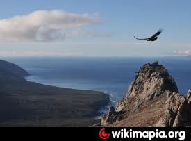


Mitre Peninsula is the easternmost part of Isla Grande de Tierra del Fuego, located in the very southeast of the island, with its easternmost point, Cabo San Diego, 29 km northwest of Isla de los Estados, from which it is separated by Le Maire Strait. In the south, the peninsula is bounded by the Beagle Channel, and in the north by the Argentine Sea. It is under 4000 km² in area. The highest peak is Cerro Campana in the southern Montes Negros range with 1026 meters. Monte Atocha is nearby southwest.
The peninsula was named by explorer Julio Popper to honor Bartolomé Mitre.
The peninsula was named by explorer Julio Popper to honor Bartolomé Mitre.
Wikipedia article: http://en.wikipedia.org/wiki/Mitre_Peninsula
Nearby cities:
Coordinates: 54°46'58"S 65°33'7"W
- Hardy Peninsula, Hoste Island 205 km
- Rous Peninsula, Hoste Island 274 km
- Brecknock Peninsula 420 km
- Brunswick Peninsula 500 km
- Antarctic Peninsula 1155 km
- Taitao Peninsula 1229 km
- Area Natural Protegida Peninsula Valdes 1417 km
- Rydberg Peninsula 2146 km
- Fletcher Peninsula 2278 km
- Kings Peninsula 2650 km
- Luz Lagoon 12 km
- Laguna Rio Bueno 19 km
- Monte Atocha 20 km
- Bahía Buen Suceso. 20 km
- Bahia Aguirre 26 km
- Strait of Le Maire 36 km
- Cape Sur (South Cape) 53 km
- Crossley Bay 55 km
- Franklin Bay 56 km
- Isla de los Estados 82 km